AI Terminal
EAST STAR RESOURCES PLC
Regulatory Filings • Nov 27, 2025
5065_bfr_2025-11-27_f7a313be-eabb-4216-9d0b-1c598a0e533e.html
Regulatory Filings
Open in ViewerOpens in native device viewer
National Storage Mechanism | Additional information 
RNS Number : 3187J
East Star Resources PLC
27 November 2025
27 November 2025
East Star Resources Plc
("East Star" or the "Company")
Two New Porphyry Licences Awarded
East Star Resources Plc (LSE:EST), the Kazakhstan-focused gold and base metals explorer, is pleased to announce it has been awarded two new licences in the Balkash-Ili Arc in Kazakhstan. The new licences comprise the Piket and Judzha projects. The licences were acquired under the first-come-first-serve system in Kazakhstan as a result of desktop and field studies targeting copper porphyry deposits.
Highlights:
· Two licences, prospective for Cu-Au porphyry and related systems have been granted to East Star
· Very large 8km x 3km alteration system in the Piket licence, dominated by Advanced Argillic Alteration; similar age and setting to the Macquarie Arc in Australia which is host to world class Cu-Au porphyry and epithermal deposits
· Anomalous gold up to 0.27g/t recorded in rock chips from Piket Project
· Anomalous silver up to 4.56g/t recorded in breccias from the Judzha Project
Alex Walker, CEO of East Star Resources, commented:
"The East Star team has worked hard over the last two field seasons to generate and assess more than 20 areas prospective for porphyry and epithermal gold deposits. As a result, we are excited to announce the grant of the next two licences in the portfolio prospective for copper porphyry deposits. Since applying for the licences, the team has mapped the prospects, laying the foundation for the next season's fieldwork. While the Licences are situated within the joint venture area of interest with Endeavour Mining, the targeting was focussed on copper porphyry deposits and so have been excluded from the joint venture."
Next Steps
Data collection and compilation from the state archives is ongoing and will be completed over the Kazakh winter season. The key focus of this work is to understand what work was completed by the Soviets and to compile the historical assay results from the multiple trenches, which have been identified through mapping at the two projects. Additionally, rock chips from recent mapping will be submitted for assay once the data compilation is completed, in time to inform the work programme for the 2026 field season.
The Piket Project
The Piket Project ("Piket") is located approximately 80km south of the city of Karaganada and approximately 20km west of the town of Shopa on the main Astana-Almaty highway, with excellent access to the project area via a network of farm tracks. The project appears as a large volcanic edifice composed of a central core of variably altered andesitic volcanic rocks, which has been intruded by a monzonite in the south. Figures 1 and 2 below illustrate the results of the recently completed Piket mapping.
The project displays the following key attributes, which demonstrate its potential fertility:
1. Anomalous geochemistry: Initial rock chip samples returned up to 0.269 g/t gold in quartz veins along the eastern margin of the intrusive. This highly anomalous gold is regarded as a strong indicator of system fertility. Additionally, epithermal veins, which were trenched in Soviet times, have been identified around 5km to the east of Piket. These veins demonstrate the preservation of the epithermal environment.
2. Extensive alteration: Piket displays extensive argillic alteration in the north and the south and at least two areas of extensive alunite veining have been observed through the mapping. Alteration is strongest in the southern part of the license area with extensive quartz-pyrophyllite alteration observed at surface. Pyrophyllite is diagnostic of the higher temperature parts of the porphyry lithocap environment and is used a key vector to the hottest and therefore most prospective parts of the system.
3. Alkaline affinity: The monzonitic rocks in the project area display alkalic alteration, which is a key feature of other prospective porphyry belts, such as the Macquarie Arc in Australia. The arc has produced world class Cu and Au bearing porphyry systems, such as Cadia-Ridgeway and North Parkes. Recognition of this alkalic intrusive event supports the potential for exploration for this style of mineralisation, which has been hitherto unrecognised in Kazakhstan.
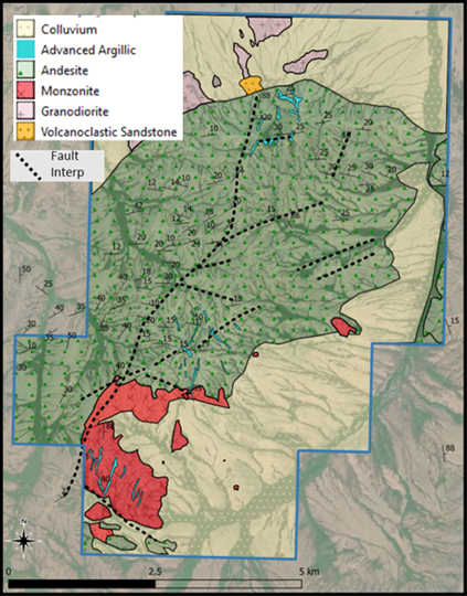 |
| Figure 1 - Piket Geological Map |
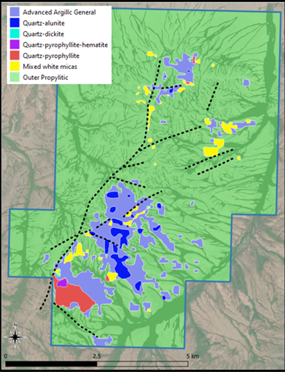 |
| Figure 2 - Piket Alteration Map |
The Judzha Project
The Judzha Project ("Judzha") is located approximately 100km northwest of the city of Balkhash and approximately 40km west of the main Astana-Almaty highway, with good access to the project area via a network of dirt roads.
Judzha hosts a large lithocap composed of a central core of hematitic breccias surrounded by intermediate volcanic rocks that intrude the granitic basement.
Figures 3 and 4 below show the results of the recently completed Judzha mapping.
The prospect displays the following attributes which demonstrate its potential fertility:
1. Multiple breccia events: Judzha was clearly a very active hydrothermal system with multiple overprinting breccia events, including intrusive breccias, hydrothermal breccias, and phreatomagmatic breccias.
2. Extensive evidence of sulfides with pyrite preserved on the margins of the system and relic sulfides now overprinted by hematite throughout the core of the system.
3. Epithermal textures observed in places with examples of vugs containing comb quartz, characteristic of the epithermal environment.
4. High-level geochemical anomalism including a peak result of up to 4.56g/t Ag in rock chips.
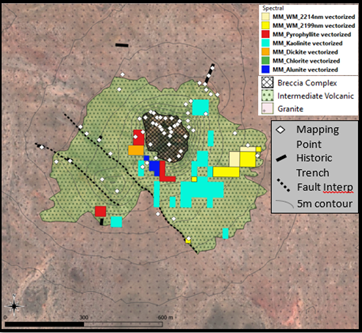 |
| Figure 3 - Judzha Geological Map |
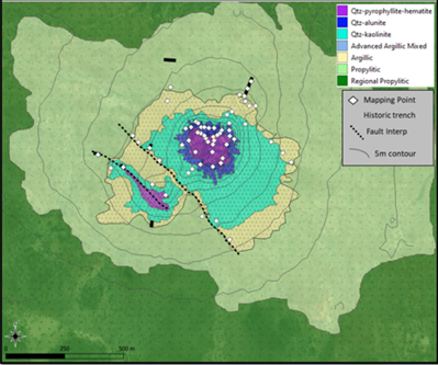 |
| Figure 4 - Judzha Alteration Map |
Contacts:
East Star Resources Plc
Alex Walker, Chief Executive Officer
Tel: +44 (0)20 7390 0234 (via Vigo Consulting)
SI Capital (Corporate Broker)
Nick Emerson
Tel: +44 (0)1483 413 500
Vigo Consulting (Investor Relations)
Ben Simons / Peter Jacob
Tel: +44 (0)20 7390 0234
About East Star Resources Plc
East Star Resources is focused on the discovery and development of copper and gold in Kazakhstan. The Company is pursuing multiple exploration strategies including:
· Volcanogenic massive sulphide (VMS) exploration, which to date includes a deposit with a maiden JORC MRE of 20.3Mt @ 1.16% copper, 1.54% zinc and 0.27% lead, in an infrastructure-rich region, amenable to a low capex development
· Copper porphyry and epithermal gold exploration, with multiple opportunities for Tier 1 deposits and a $25 million+ strategic JV agreement with Endeavour Mining for gold exploration
Visit our website:
Follow us on social media:
LinkedIn: https://www.linkedin.com/company/east-star-resources/
Subscribe to our email alert service to be notified whenever East Star releases news:
www.eaststarplc.com/newsalerts
The person who arranged for the release of this announcement was Alex Walker, CEO of the Company.
Competent Person Statement
Scientific or technical information in this disclosure related to exploration was reviewed by Dr Tremain Woods, a full-time employee of Discovery Ventures Kazakhstan Ltd, a 100% owned subsidiary of East Star Resources PLC. Dr Woods is a member in good standing with the Geological Society of South Africa. He has sufficient experience that is relevant to the commodity, style of mineralisation or type of deposit under consideration and activity which he is undertaking to qualify as a Competent Person under the JORC code (2012 Edition).
The person who arranged for the release of this announcement was Alex Walker, CEO of the Company.
This announcement contains inside information for the purposes of Article 7 of Regulation 2014/596/EU which is part of domestic UK law pursuant to the Market Abuse (Amendment) (EU Exit) Regulations (SI 2019/310) ("UK MAR"). Upon the publication of this announcement, this inside information (as defined in UK MAR) is now considered to be in the public domain.
Table 1 Rock Chip results by Project
| SampleID | NAT_North | NAT_East | Project | Cu_ppm | Au_ppm | Ag_ppm |
| R10912 | 5257655 | 425142 | Judzha | 3.54 | 0.0011 | 0.512 |
| R10913 | 5257542 | 424991 | Judzha | 5.17 | 0.0042 | 4.56 |
| R10914 | 5257533 | 424996 | Judzha | 20.4 | 0.0028 | 0.58 |
| R10915 | 5257426 | 424968 | Judzha | 2.49 | 0.022 | 0.346 |
| R10916 | 5257410 | 424938 | Judzha | 9.02 | 0.0127 | 0.909 |
| R10917 | 5257368 | 424923 | Judzha | 4.85 | 0.0062 | 0.317 |
| R10918 | 5257282 | 424853 | Judzha | 14.6 | 0.0062 | 1.38 |
| R10919 | 5257178 | 424627 | Judzha | 18.1 | 0.0035 | 0.163 |
| R10920 | 5257109 | 424624 | Judzha | 6.82 | 0.0039 | 0.255 |
| R10921 | 5257015 | 424599 | Judzha | 14.05 | 0.0079 | 0.518 |
| R12740 | 5440784 | 370317 | Piket | 5.96 | 0.001 | 0.068 |
| R12741 | 5440572 | 370330 | Piket | 6.98 | 0.001 | 0.101 |
| R12742 | 5440568 | 370350 | Piket | 6.01 | -0.001 | 0.074 |
| R12743 | 5440430 | 370474 | Piket | 6.46 | -0.001 | 0.095 |
| R12744 | 5440562 | 370589 | Piket | 10.1 | -0.001 | 0.183 |
| R12745 | 5440511 | 370454 | Piket | 14.65 | -0.001 | 0.214 |
| R12746 | 5443817 | 374030 | Piket | 2.65 | 0.005 | 0.043 |
| R12747 | 5442059 | 373060 | Piket | 3.12 | 0.003 | 0.029 |
| R12748 | 5437583 | 371165 | Piket | 9.17 | 0.02 | 0.154 |
| R12749 | 5437712 | 371109 | Piket | 32.1 | 0.113 | 0.101 |
| R12750 | 5437686 | 371005 | Piket | 9.02 | 0.269 | 0.183 |
| R12751 | 5438433 | 370159 | Piket | 46.4 | 0.018 | 0.394 |
Table 2 - JORC Code, 2012 Edition
Section 1 Sampling Techniques and Data
| Criteria | JORC Code explanation | Commentary |
|---|---|---|
| Sampling techniques | · Nature and quality of sampling (e.g. cut channels, random chips, or specific specialised industry standard measurement tools appropriate to the minerals under investigation, such as down hole gamma sondes, or handheld XRF instruments, etc). These examples should not be taken as limiting the broad meaning of sampling. · Include reference to measures taken to ensure sample representivity and the appropriate calibration of any measurement tools or systems used. · Aspects of the determination of mineralisation that are Material to the Public Report. · In cases where 'industry standard' work has been done this would be relatively simple (e.g. 'reverse circulation drilling was used to obtain 1 m samples from which 3 kg was pulverised to produce a 30 g charge for fire assay'). In other cases, more explanation may be required, such as where there is coarse gold that has inherent sampling problems. Unusual commodities or mineralisation types (e.g. submarine nodules) may warrant disclosure of detailed information. |
· Samples were taken from fresh in situ outcrops at surface, where ever fresh outcrop showed features of interest such as veining, sulphides, oxide material and strong alteration · Samples were taken until a standard sample bag was half filled - approximately 1 - 5 kg of material · Mineralisation was identified by inspection of fresh surfaces of the samples, mineralisation included both sulphide and oxides · Historical samples are not available at the time of this press release |
| Drilling techniques | · Drill type (e.g. core, reverse circulation, open-hole hammer, rotary air blast, auger, Bangka, sonic, etc) and details (e.g. core diameter, triple or standard tube, depth of diamond tails, face-sampling bit or other type, whether core is oriented and if so, by what method, etc). | · N/A |
| Drill sample recovery | · Method of recording and assessing core and chip sample recoveries and results assessed. · Measures taken to maximise sample recovery and ensure representative nature of the samples. · Whether a relationship exists between sample recovery and grade and whether sample bias may have occurred due to preferential loss/gain of fine/coarse material. |
· N/A |
| Logging | · Whether core and chip samples have been geologically and geotechnically logged to a level of detail to support appropriate Mineral Resource estimation, mining studies and metallurgical studies. · Whether logging is qualitative or quantitative in nature. Core (or costean, channel, etc) photography. · The total length and percentage of the relevant intersections logged. |
· N/A |
| Sub-sampling techniques and sample preparation | · If core, whether cut or sawn and whether quarter, half or all core taken. · If non-core, whether riffled, tube sampled, rotary split, etc and whether sampled wet or dry. · For all sample types, the nature, quality, and appropriateness of the sample preparation technique. · Quality control procedures adopted for all sub-sampling stages to maximise representivity of samples. · Measures taken to ensure that the sampling is representative of the in-situ material collected, including for instance results for field duplicate/second-half sampling. · Whether sample sizes are appropriate to the grain size of the material being sampled. |
· N/A |
| Quality of assay data and laboratory tests | · The nature, quality and appropriateness of the assaying and laboratory procedures used and whether the technique is considered partial or total. · For geophysical tools, spectrometers, handheld XRF instruments, etc, the parameters used in determining the analysis including instrument make and model, reading times, calibrations factors applied and their derivation, etc. · Nature of quality control procedures adopted (e.g. standards, blanks, duplicates, external laboratory checks) and whether acceptable levels of accuracy (i.e. lack of bias) and precision have been established. |
· Nature, quality and appropriateness of assaying and laboratory procedures: o Samples analysed at ALS Karaganda (Kazakhstan), an ISO-compliant facility. o Multi-element suite by ME-MS41L (aqua-regia digestion, ICP-MS) - near-total for most elements, partial for refractory minerals; appropriate for early-stage exploration. o Gold by AU-ICP21 (30 g fire assay, ICP-AES finish) - total technique, industry standard. o HYP-PKG hyperspectral logging (HyLogger-3™) for alteration/lithology mapping - non-destructive and suitable for early exploration. o Techniques are considered fit-for-purpose for the exploration stage · Geophysical tools, spectrometers, handheld XRF instruments o No geophysical tools or handheld XRF used for reported results. o Hyperspectral data acquired with HyLogger-3™ (380-14,500 nm); daily calibration with certified standards. · Nature of quality control procedures adopted o At this early stage, no field duplicates, blanks or CRMs were inserted by the company. o Full reliance placed on ALS Karaganda internal laboratory QA/QC (reagent blanks, certified standards, duplicates and repeats inserted by the laboratory at regular intervals). · Acceptable levels of accuracy and precision: o Laboratory internal QC results supplied with every batch showed all standards within acceptable limits, no significant bias, and duplicate precision typically <10 % RSD. o Accuracy and precision are considered acceptable for early-stage exploration reporting. |
| Verification of sampling and assaying | · The verification of significant intersections by either independent or alternative company personnel. · The use of twinned holes. · Documentation of primary data, data entry procedures, data verification, data storage (physical and electronic) protocols. · Discuss any adjustment to assay data. |
· N/A |
| Location of data points | · Accuracy and quality of surveys used to locate drill holes (collar and down-hole surveys), trenches, mine workings and other locations used in Mineral Resource estimation. · Specification of the grid system used. · Quality and adequacy of topographic control. |
· Locations were surveyed using Garmin GPSMAP 62S handheld GPS device or mobile phone GPS device. · Grid system WGS84, UTM43N. · The quality and accuracy of handheld/mobile GPS devices is approximately 3 m in the X and Y directions and 12 m in the Z direction. The accuracy is considered acceptable for early-stage exploration |
| Data spacing and distribution | · Data spacing for reporting of Exploration Results. · Whether the data spacing and distribution is sufficient to establish the degree of geological and grade continuity appropriate for the Mineral Resource and Ore Reserve estimation procedure(s) and classifications applied. · Whether sample compositing has been applied. |
· N/A |
| Orientation of data in relation to geological structure | · Whether the orientation of sampling achieves unbiased sampling of possible structures and the extent to which this is known, considering the deposit type. · If the relationship between the drilling orientation and the orientation of key mineralized structures is considered to have introduced a sampling bias, this should be assessed and reported if material. |
· N/A |
| Sample security | · The measures taken to ensure sample security. | · Sample security is unclear and cannot be verified by East Star. |
| Audits or reviews | · The results of any audits or reviews of sampling techniques and data. | · No audits were undertaken for this work. |
Section 2 Reporting of Exploration Results
Criteria
JORC Code explanation
Commentary
Mineral tenement and land tenure status
· Type, reference name/number, location and ownership including agreements or material issues with third parties such as joint ventures, partnerships, overriding royalties, native title interests, historical sites, wilderness or national park and environmental settings.
· The security of the tenure held at the time of reporting along with any known impediments to obtaining a licence to operate in the area.
· The Judzha Exploration license (3724-EL) is registered to Discovery Ventures Kazakhstan Limited, an AIFC registered entity 100% owned by East Star Resources PLC. The license was awarded on 14 November 2025 and is valid for 6 years.
· The Piket Exploration license (3720-EL) is registered to Discovery Ventures Kazakhstan Limited, an AIFC registered entity 100% owned by East Star Resources PLC. The license was awarded on 10 November 2025 and is valid for 6 years.
· All requirements for owning the licenses, including insurances, have been fulfilled
· There are no known legal or security impediments to holding the exploration licenses and obtaining mining licenses.
Exploration done by other parties
· Acknowledgment and appraisal of exploration by other parties.
· Table of previously completed exploration at Piket
| Principal author, year | Period | Exploration | Results |
|---|---|---|---|
| M. Reshko and et al., 1966 | 1964-1966 | Сomprehensive geological survey at 1:50,000 scale. Completed: mapping, drilling, trenching, test pitting, and sampling | Within the license boundary identified alunite and diaspore mineral occurrences - Symbyl-1, Symbyl-2 and Kosmurun |
· Table of previously completed exploration at Judzha
| Principal author, year | Period | Exploration | Results |
|---|---|---|---|
| G. Zhakupov et al., 1965 | 1962-1964 | 1:50 000-scale geological survey and exploration for regional prospectivity assessment and preparation of geological, metallogenic, and forecast maps. | The report presents the results of stream sediment and hydrochemical surveys, trench and metalometric sampling, geophysical studies (magnetic, SP, IP), drilling and mining works, and gamma surveys. |
| N. Kochkin et al., 1965 | 1962-1964 | 1:50 000-scale geological survey for mineral deposit exploration | Within the license area delineated Judzha ore occurrence. Agadyr GEP conducted a metallometric survey, magnetic and electrical works (SP and IP), and exploratory drilling. |
| S. Starodubcev et al., 1980 | 1976-1980 | 1:50 000-scale geological follow-up studies and prospecting aimed at discovering copper, polymetallic, and rare-metal deposits | Updated information on stratigraphy, tectonics, magmatic activity, and mineral resources has been obtained. Several new ore occurrences and mineralization points were discovered, while geochemical analyses highlighted numerous copper, molybdenum, lead, and zinc anomalies. |
| I. Kolesnikov et al., 1990 | 1986-1990 | 1:50 000-scale deep exploration for copper, rare, radioactive metals, gold in areas covered by unconsolidated sedimentary overburden | Drilling, sampling, electrical surveys, and geochemical studies were carried out. Identified prospective mineralization areas, and given recommendations for detailed geological and geophysical works. |
| I. Shuvalov et al., 1992 | 1978-1990 | 1:50 000-scale geological follow-up studies and prospecting carried out by the Uzunzhalskaya party, and regional geophysical surveys completed by the Airtau geophysical team. | The report outlines the results of 1:50 000-scale geological follow-up studies and the accompanying geophysical, geochemical, drilling, and other works that support the overall evaluation of forecast mineral resources. It also summarizes the results of detailed integrated prospecting conducted across several polymetallic occurrences. |
Geology
· Deposit type, geological setting, and style of mineralisation.
· Judzha
o The license area is hosted in volcanic-sedimentary sequences, with an intrusive breccia complex in the centre. The geology and alteration indicates an alkaline porphyry intrusion
o While unknown at this stage, ESR is exploring for porphyry style mineralisation and associated deposits
· Piket
o The license area is hosted in volcanic-sedimentary sequences intruded by monzonites, with an intrusive breccia complex in the centre. The geology and alteration indicates an alkaline porphyry intrusion
o While unknown at this stage, ESR is exploring for porphyry style mineralisation and associated deposits
Drill hole Information
· A summary of all information material to the understanding of the exploration results including a tabulation of the following information for all Material drill holes:
o easting and northing of the drill hole collar
o elevation or RL (Reduced Level - elevation above sea level in metres) of the drill hole collar
o dip and azimuth of the hole
o down hole length and interception depth
o hole length.
· If the exclusion of this information is justified on the basis that the information is not Material and this exclusion does not detract from the understanding of the report, the Competent Person should clearly explain why this is the case.
· N/A
Data aggregation methods
· In reporting Exploration Results, weighting averaging techniques, maximum and/or minimum grade truncations (e.g. cutting of high grades) and cut-off grades are usually Material and should be stated.
· Where aggregate intercepts incorporate short lengths of high-grade results and longer lengths of low-grade results, the procedure used for such aggregation should be stated and some typical examples of such aggregations should be shown in detail.
· The assumptions used for any reporting of metal equivalent values should be clearly stated.
· N/A
Relationship between mineralisation widths and intercept lengths
· These relationships are particularly important in the reporting of Exploration Results.
· If the geometry of the mineralisation with respect to the drill hole angle is known, its nature should be reported.
· If it is not known and only the down hole lengths are reported, there should be a clear statement to this effect (e.g. 'down hole length, true width not known').
· The nature of any potential ore bodies is not known at this stage of exploration.
Diagrams
· Appropriate maps and sections (with scales) and tabulations of intercepts should be included for any significant discovery being reported These should include but not be limited to a plan view of drill hole collar locations and appropriate sectional views.
· Relevant diagrams have been included in the body text.
Balanced reporting
· Where comprehensive reporting of all Exploration Results is not practical, representative reporting of both low and high grades and/or widths should be practiced to avoid misleading reporting of Exploration Results.
· N/A
Other substantive exploration data
· Other exploration data, if meaningful and material, should be reported including (but not limited to): geological observations; geophysical survey results; geochemical survey results; bulk samples - size and method of treatment; metallurgical test results; bulk density, groundwater, geotechnical and rock characteristics; potential deleterious or contaminating substances.
· N/A
Further work
· The nature and scale of planned further work (e.g. tests for lateral extensions or depth extensions or large-scale step-out drilling).
· Diagrams clearly highlighting the areas of possible extensions, including the main geological interpretations and future drilling areas, provided this information is not commercially sensitive.
· East star is planning to soil sample and analyse samples taken over the winter months in Kazakhstan
· Additional work programmes will be designed based on the outcomes of the soils
This information is provided by RNS, the news service of the London Stock Exchange. RNS is approved by the Financial Conduct Authority to act as a Primary Information Provider in the United Kingdom. Terms and conditions relating to the use and distribution of this information may apply. For further information, please contact [email protected] or visit www.rns.com.
RNS may use your IP address to confirm compliance with the terms and conditions, to analyse how you engage with the information contained in this communication, and to share such analysis on an anonymised basis with others as part of our commercial services. For further information about how RNS and the London Stock Exchange use the personal data you provide us, please see our Privacy Policy.
END
UPDPKOBDBBDDPDB