AI Terminal
Alien Metals Limited
Regulatory Filings • Nov 5, 2025
10419_rns_2025-11-05_eb117654-b38a-4ac5-8b98-dead3623bdeb.html
Regulatory Filings
Open in ViewerOpens in native device viewer
National Storage Mechanism | Additional information 
RNS Number : 1949G
Alien Metals Limited
05 November 2025

THIS ANNOUNCEMENT CONTAINS INSIDE INFORMATION FOR THE PURPOSES OF ARTICLE 7 OF THE MARKET ABUSE REGULATION (596/2014/EU) AS THE SAME HAS BEEN RETAINED IN UK LAW AS AMENDED BY THE MARKET ABUSE (AMENDMENT) (EU EXIT) REGULATIONS (SI 2019/310). UPON THE PUBLICATION OF THIS ANNOUNCEMENT, THIS INSIDE INFORMATION IS NOW CONSIDERED TO BE IN THE PUBLIC DOMAIN.
NOT FOR RELEASE, PUBLICATION OR DISTRIBUTION IN WHOLE OR IN PART, DIRECTLY OR INDIRECTLY IN, INTO OR FROM ANY JURISDICTION WHERE TO DO SO WOULD CONSTITUTE A VIOLATION OF THE RELEVANT LAWS OR REGULATIONS OF SUCH JURISDICTION.
Trading Symbols
AIM: UFO
FWB: I3A1
5 November 2025
Alien Metals Limited
("Alien" or the "Company")
Native Silver intersected in drilling at Elizabeth Hill Silver Project
Alien Metals Limited (AIM: UFO), a minerals exploration and development company, is pleased to report that its joint venture partner, West Coast Silver Limited (ASX: WCE) ("West Coast Silver") has announced that shallow visual native silver and related silver-bearing minerals have been confirmed in four of the five initial drill holes intersecting the up-plunge position of the historically mined Elizabeth Hill Silver Project ("Elizabeth Hill" or the "Project") in the Pilbara region of Western Australia. The Project, in which Alien retains a 30% free-carried interest through to a decision to mine, is operated by West Coast Silver.
Belinda Murray, Executive Director of Alien, commented:
"It is very encouraging to see West Coast Silver continue to deliver such strong early results from its drilling at Elizabeth Hill, including the identification of visible native silver close to surface. These results further reinforce the exceptional potential of one of Australia's highest-grade historical silver deposits. "
The full text of the announcement issued by West Coast Silver is provided below in Appendix A.
For further information, please visit the Company's website at www.alienmetals.uk or contact:
Strand Hanson (Financial and Nominated Adviser)
James Harris / James Dance / Edward Foulkes
Tel: +44 (0) 207 409 3494
Zeus Capital Limited (Joint Broker)
Harry Ansell / Katy Mitchell Tel +44 (0) 203 829 5000
Turner Pope (Joint Broker)
Andy Thacker / James Pope
Tel: +44 (0) 203 657 0050
CMC Markets (Joint Broker)
Douglas Crippen
Tel: +44 (0) 203 003 8632
Yellow Jersey (Financial PR)
Charles Goodwin / Shivantha Thambirajah
Tel: +44 (0) 203 004 9512
Notes to Editors
Alien Metals Ltd is a mining exploration and development company listed on the AIM market of the London Stock Exchange (AIM: UFO). The Company's focus is on delivering a profitable direct shipping iron ore operation from its 90% Hancock iron ore project in the central Pilbara region of Western Australia. The Hancock tenements currently contain a JORC-compliant resource of 8.4Mt iron ore @ 60% Fe and offers significant exploration upside which is targeted to deliver a mining operation of 2Mtpa for 10 years.
These Hancock Project tenements have direct access to the Great Northern Highway, which provides an essential export route to export facilities at Port Hedland, from where more than 500Mt of iron ore is exported annually (30% of global production). The Company also has an interest in two iron ore exploration projects Brockman and Vivash, located in the West Pilbara.
The Company owns one of Australia's largest PGM deposits, Munni Munni which hosts a deposit containing a historic resource of 2.2Moz PGM (Palladium, Platinum, and Rhodium) and Gold. The Company has recently entered into a joint venture with West Coast Silver Limited (formerly Errawarra Resources Limited) for the development of the Elizabeth Hill Silver Project, located near Karratha in the Pilbara, which consists of the Elizabeth Hill Mining Lease and exploration tenements surrounding the historical silver mine which has produced some of Australia's highest-grade silver ore during the late 1990s.
Competent Person's Statement
Thomas Reddicliffe, BSc (Hons), MSc, a Director and Shareholder of the Company, is a Fellow of the AUSIMM, and has sufficient experience which is relevant to the style of mineralisation and type of deposit under consideration to qualify as a Competent Person as defined in the 2012 edition of the 'Australasian Code for Reporting of Exploration Results, Mineral Resources and Ore Reserves'. Thomas Reddicliffe consents to the inclusion in the report of the information in the form and context in which it appears.
Appendix A - ASX: WCE ANNOUNCEMENT
Native Silver intersected in drilling at Elizabeth Hill Silver Project
Highlights
· Initial five drill holes successfully completed intersecting the up-plunge position of the historically mined high grade Elizabeth Hill silver deposit
· The mineralized zone is defined by quartz-carbonate veining/stockwork and host to native silver, related silver minerals and base metals
· Native silver visually identified in two drill holes and confirmed through pXRF[1] analysis
· Native Silver in hole 25WCDD014 is visually significant and occurs in 3 separate intervals
· ~1,300m diamond drilling program is projected to conclude mid-November
· Silver mineralisation has been identified in drill holes 25WCDD013, 14, 16 & 17 (Figures 1 - 7)
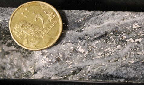
Figure 1: Photograph of cut half HQ3 drill core (25WCDD014) from 53.68m to 53.75m
West Coast Silver Limited (ASX: WCE) ("West Coast Silver" or the "Company") is pleased to advise that the follow up diamond drill program to the inaugural diamond drilling at the high-grade historic Elizabeth Hill Silver Project in the Pilbara (Western Australia) has delivered an exceptional start, with shallow visual native silver and related silver-bearing minerals confirmed in four of the first five holes completed (Figure 8, Appendix 1).
Commenting on the results, Executive Chairman Bruce Garlick said:
"We are extremely pleased with this exceptional start to our follow up drill program. To intersect Native silver in two drill holes and silver-bearing minerals in another two holes close to surface is a tremendous result and validates our belief in the near-surface potential at Elizabeth Hill.
Drill Hole Mineralisation: Visual Observations/pXRF
Throughout the drilling process, all drill holes undergo geological logging to assess lithology, alteration, and mineralisation. In four of the initial five completed drillholes, native silver and/or silver minerals were identified and verified using a Vanta portable XRF ("pXRF") device. It is important to note that while pXRF readings provide valuable insights, they should not be considered a substitute for thorough laboratory analysis. These readings reflect elemental concentrations at specific locations rather than providing a comprehensive overview of the entire rock sample.
WCE emphasises that visual estimates of mineral abundance should not be regarded as a proxy or substitute for laboratory analyses, particularly when concentrations or grades are of primary economic significance. Furthermore, visual estimates do not yield information concerning impurities or detrimental physical properties that are pertinent to valuations.
Description of silver mineralisation
Drill hole 25WCDD014
Diamond drill hole 25WCDD014 contained three intervals of native silver mineralisation identified by geological logging and confirmed by pXRF analysis (Appendix 2). The geologically logged intervals of native silver mineralisation occur within the following intervals of the core photos below:
· 53.57m to 54.07m - 1% to 2% observed native silver (Figure 2).
· 66.24m to 66.42m - 1% observed native silver (Figure 3).
· 74.52m to 74.95m - 1% observed native silver (Figure 4).
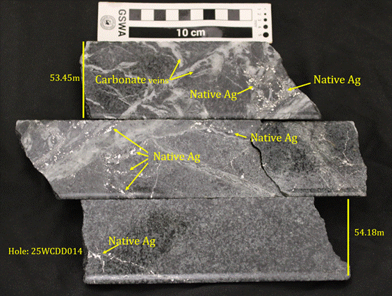
Figure 2: Photograph of cut half HQ3 drill core (25WCDD014) from 53.45m to 54.18m showing 2mm to 4mm grains of native silver hosted within and adjacent to 1cm to 3cm thick carbonate veins in an ultramafic host rock. The native silver content is estimated at 1% to 2% by volume.

Figure 3: Photograph of cut half HQ3 drill core (25WCDD014) from 65.96m to 66.60m showing 1% visually estimated, 2mm to 3mm long native silver grains hosted in and adjacent to 1cm to 10cm thick carbonate veins in an ultramafic host rock.

Figure 4: Photograph of cut half HQ3 drill core (25WCDD014) from 74.42m to 75.11m showing 1% visually estimated, 2mm to 4mm long native silver grains hosted within and adjacent to 1cm to 3cm thick carbonate veins in an ultramafic host rock.
Drill hole 25WCDD013
Diamond drill hole 25WCDD013 contained approximately 5%, brown, oxidised carbonate-quartz veins, up to 5cm wide, from 14.80m to 16.60m depth (Figure 5). Within and adjacent to these veins, black, secondary minerals (1%), ranging from1mm to 2mm in size, were identified and have been confirmed by pXRF to contain silver (Appendix 2).
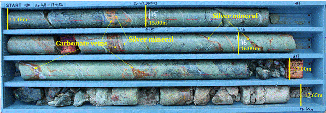
Figure 5: Photograph of HQ3 diamond drill core (25WCDD013) from 14.48m to 17.65m showing several, up to 5cm wide, carbonate-quartz veins with 1mm to 2mm black silver-bearing minerals (1%) confirmed by pXRF in moderately weathered ultramafic host rock.
CAUTIONARY STATEMENT
It is important to note that while pXRF readings provide valuable insights, they should not be considered a substitute for thorough laboratory analysis. These readings reflect elemental concentrations at specific locations rather than providing a comprehensive overview of the entire rock sample.
WCE emphasises that visual estimates of mineral abundance should not be regarded as a proxy or substitute for laboratory analyses, particularly when concentrations or grades are of primary economic significance. Furthermore, visual estimates do not yield information concerning impurities or detrimental physical properties that are pertinent to valuations.
Drill hole 25WCDD016
Diamond drill hole 25WCDD016 showed black oxidised minerals up to 2cm long and approximately 1% of the breccia from 44.59m to 44.61m (Figure 6). These minerals are hosted in a carbonate-matrix breccia and pXRF confirmed the presence of silver in this mineral (Appendix 2).
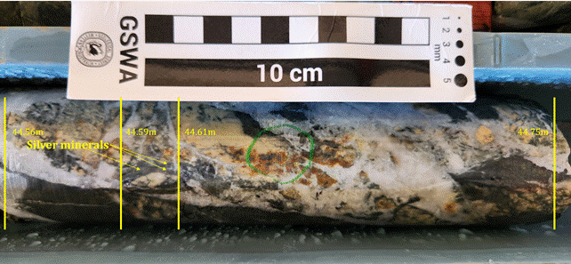
Figure 6: Photograph of HQ3 diamond drill core (25WCDD016) from 44.56m to 44.75m showing several up to 2cm long black minerals from 44.59m to 44.61m forming approximately 1% of the breccia. These minerals are hosted in a carbonate-matrix breccia and pXRF confirmed the presence of silver in the black mineral.
CAUTIONARY STATEMENT
It is important to note that while pXRF readings provide valuable insights, they should not be considered a substitute for thorough laboratory analysis. These readings reflect elemental concentrations at specific locations rather than providing a comprehensive overview of the entire rock sample.
WCE emphasises that visual estimates of mineral abundance should not be regarded as a proxy or substitute for laboratory analyses, particularly when concentrations or grades are of primary economic significance. Furthermore, visual estimates do not yield information concerning impurities or detrimental physical properties that are pertinent to valuations.
Drill hole 25WCDD017
Diamond drill hole 25WCDD017 contained trace amounts of observed native silver, occurring as 1mm to 2mm grains at 43.61m within a quartz vein in a late fracture (Figure 7), and were confirmed by pXRF (Appendix 2).
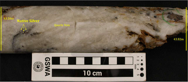
Figure 7. Photograph of HQ3 diamond drill core (25WCDD017) from 43.58m to 43.82m showing several up to 2mm wide native silver grains (<0.5%) confirmed by pXRF within a massive quartz vein.
CAUTIONARY STATEMENT
It is important to note that while pXRF readings provide valuable insights, they should not be considered a substitute for thorough laboratory analysis. These readings reflect elemental concentrations at specific locations rather than providing a comprehensive overview of the entire rock sample.
WCE emphasises that visual estimates of mineral abundance should not be regarded as a proxy or substitute for laboratory analyses, particularly when concentrations or grades are of primary economic significance. Furthermore, visual estimates do not yield information concerning impurities or detrimental physical properties that are pertinent to valuations.
Drill hole 25WCDD015
Diamond drill hole 25WCDD015 did not contain any observable silver mineralisation and no significant silver was detected in the pXRF (Appendix 2). Laboratory analysis is required to determine the presence or absence of silver in this drill hole.
Drill Plan and location of silver mineralisation
Drill holes were planned to intersect and verify near surface mineralisation in historical drill holes at the northern end of previous underground workings (Figure 8).
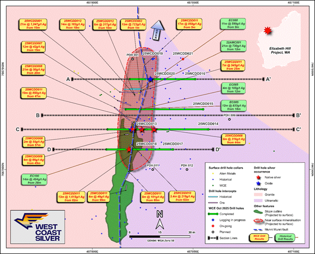
Figure 8. Map showing the geological setting, location of drill holes which contained native silver and silver oxide and sulphide minerals and selected historical drill results
Note: Call out results in Figure 8 have previously been shown in ASX Announcement dated 15 October 2025
Cross Sections and location of silver mineralisation
Drill holes 25WCDD013 & 25WCDD014
These drill holes were targeting the prospective interaction of the Munni Munni fault and the granite/ultramafic contact, as well as targeting mineralisation at the top of the historical Elizabeth Hill mine sequence (Figure 9).
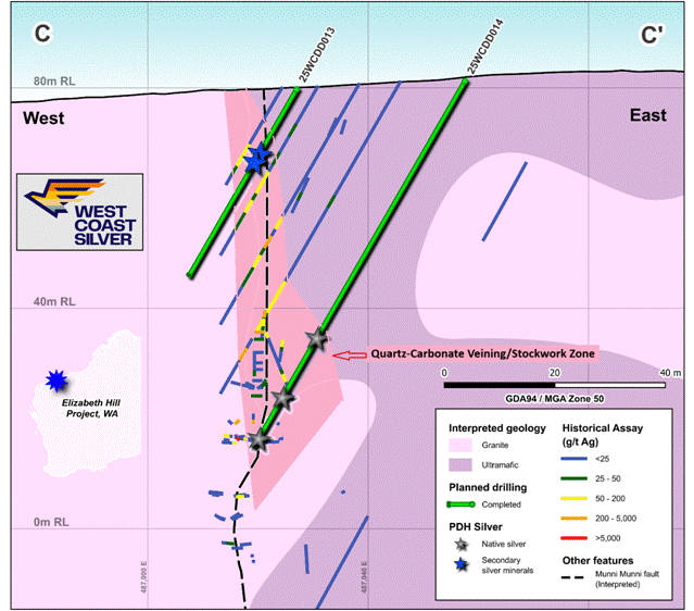
Figure 9: Cross section with historical drilling and recently completed drill holes. Diamond drill hole 25WCDD014 terminated at the top of historical underground workings
Drill hole 25WCDD016
This drill hole was targeting the prospective interaction of the Munni Munni fault and granite/ultramafic contact in the northern up plunge position representing the oxide component of the deeper, native silver and silver sulphide mineralisation (Figure 10).
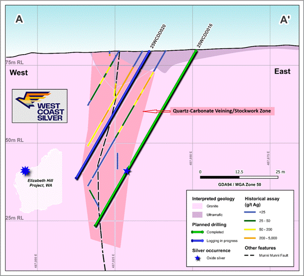
Figure 10. Cross section with historical drilling and recently completed drill hole 25WCDD016
Drill hole 25WCDD017
This drill hole was targeted to intersect the prospective ultramafic rock and granite contact as well as the Munni Munni fault above the historical underground workings (Figure 11). Drill hole 25WCDD017 was designed to twin historical reverse circulation percussion drill hole EC100 and verify its reported mineralisation (EC100: 14m @ 404g/t Ag from 28m; refer to ASX Announcement dated 16th July 2025).
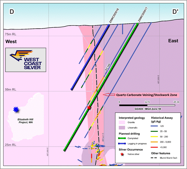
Figure 11: Cross section with historical drilling and recently completed drill hole 25WCDD017
Drill hole 25WCDD015
Drill hole 25WCDD015 intersected the Munni Munni fault and the contact between ultramafic rock and granite (Figure 12). Although no visible silver mineralisation was observed during geological logging anomalous Ag and Pb was reported in spot pXRF analyses in the down hole interval 51.18m to 59.36m. The location of this interval is consistent with mineralisation reported in nearby historic drill holes(Figure 12). The subsequent assaying of the core from this drill hole will determine the presence and extent of any silver or any associated mineralisation within this zone.

Figure 12: Cross section with historical drilling and recently completed drill hole 25WCDD015
Laboratory Testing
Core from the first three holes has been cut, and half-core has been sampled and dispatched for laboratory analysis. Core cutting and sampling activities are continuing, with analytical results expected mid-December 2025 to early January 2026 (indicative).
Ongoing drilling, sampling and submission will vary depending on drilling progress.
Result timeframes may vary pending on laboratory analysis requirements for further analysis of any over-grade silver mineralisation.
Selected samples have been submitted for expediated laboratory processing.
The Elizabeth Hill Project
Elizabeth Hill is historically one of Australia's highest grade silver projects and has a proven production history outlined below:
• High grades enabled low processing tonnes: 1.2Moz of silver was produced from just 16,830t of ore at a head grade of 2,194g/t (70.5 oz/t Ag)[2].
• Previous mining operation ceased in 2000: because of low silver prices (US$5)[3].
• Simplistic historical processing technique: native silver was recovered via low-cost gravity separation techniques.
• Untapped potential remains in ground with deposit open at depth and recent consolidation of land package offers potential to discover more Elizabeth Hill style deposits.
• Tier 1 Mining Jurisdiction located on a mining lease with potential processing option at the nearby Radio Hill site. Radio Hill is a third-party-owned processing facility; WCE has no current agreement in place."
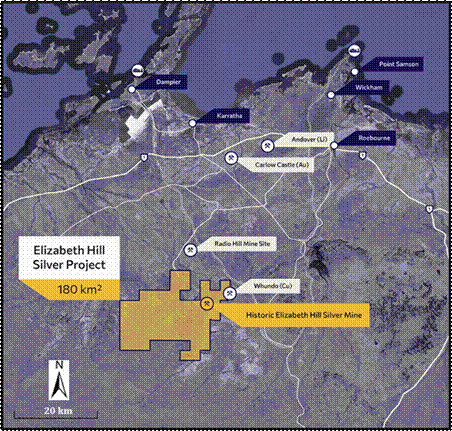
Figure 6: Tenement Location
Through the consolidation of the surrounding land packages into a single contiguous 180km2 package significant exploration and growth potential exists both near mine and regionally. The land package holds a significant portion of the Munni Munni fault system, and other fault systems subparallel to the Munni Munni fault system, which are considered prospective for Elizabeth Hill look-a-like silver deposits.
Appendix 1: Drill hole Collar Details
| Drill Hole ID | Easting (m) | Northing (m) | RL (mASL) | Azimuth (°) | Dip (°) |
Planned Depth (m) | Drilled Depth (m) | Notes |
| Planned Hole 1 | 487020 | 7667955 | 86.53 | 270 | -60 | 30 | 0 | Planned location Not yet drilled |
| 25WCDD019 | 487030 | 7667955 | 86.62 | 270 | -60 | 30.4 | Logging in progress | |
| 25WCDD021 | 487045 | 7667955 | 86.77 | 270 | -60 | 65 | 0 | Drilling in progress |
| 25WCDD016 | 487051 | 7667945 | 87.34 | 270 | -60 | 64.9 | complete | |
| 25WCDD015 | 487055 | 7667930 | 88.47 | 270 | -60 | 76.9 | complete | |
| Planned Hole 6 | 487068 | 7667930 | 89.52 | 270 | -60 | 100 | 0 | Planned location Not yet drilled |
| 25WCDD013 | 487027 | 7667920 | 87.44 | 270 | -60 | 38.9 | complete | |
| 25WCDD014 | 487057 | 7667920 | 89.27 | 270 | -60 | 76.4 | complete | |
| 25WCDD018 | 487027 | 7667910 | 87.5 | 270 | -60 | 33.5 | Logging in progress | |
| 25WCDD017 | 487040 | 7667910 | 88.2 | 270 | -60 | 66.0 | complete | |
| Planned Hole 11 | 487030 | 7667900 | 87.49 | 270 | -60 | 60 | 0 | Planned location Not yet drilled |
| Planned Hole 12 | 487047 | 7667900 | 88.74 | 270 | -60 | 90 | 0 | Planned location Not yet drilled |
| Planned Hole 13 | 487110 | 7667821 | 91.73 | 270 | -60 | 205 | 0 | Planned location Not yet drilled |
| Planned Hole 14 | 487137 | 7667822 | 91.74 | 270 | -56 | 225 | 0 | Depends on results of planned drill hole 13 |
| 25WCDD020 | 487030 | 7667945 | 87.34 | 270 | -60 | 47.0 | Logging in progress |
Appendix 2: Portable XRF Results
| Geological Log | Portable XRF | ||||||||||||
|---|---|---|---|---|---|---|---|---|---|---|---|---|---|
| Hole_ID | Depth From (m) | Depth To (m) | Interval (m) | Min 1 type | Min 1 (%) | Comments | Point Location Depth | Interpreted lithology or minerals | Ag (g/t) | Pb (g/t) | S (g/t) | Ni (g/t) | Cu (g/t) |
| --- | --- | --- | --- | --- | --- | --- | --- | --- | --- | --- | --- | --- | --- |
| 25WCDD013 | 0.00 | 0.27 | 0.27 | Colluvial soil | 1.00 | Weathered pyroxenite | 9 | <LOD | 752 | 1,291 | 649 | ||
| 25WCDD013 | 0.27 | 4.07 | 3.80 | Weakly weathered pyroxenite, ferruginisation along fractures | 2.00 | Weathered pyroxenite | 8 | <LOD | <LOD | 1,800 | 1,642 | ||
| 25WCDD013 | 3.00 | Weathered pyroxenite | <LOD | <LOD | <LOD | 1,038 | 856 | ||||||
| 25WCDD013 | 4.00 | Weathered pyroxenite | 9 | 55 | <LOD | 1,389 | 258 | ||||||
| 25WCDD013 | 4.07 | 5.29 | 1.22 | si | 5.00 | Pyroxenite with several up to 10cm granite xenoliths; abundant quartz-carbonate veining | 5.00 | Weathered pyroxenite | 13 | <LOD | <LOD | 531 | 77 |
| 25WCDD013 | 5.29 | 7.96 | 2.67 | Monotonous pyroxenite | 6.00 | Weathered pyroxenite | <LOD | <LOD | <LOD | 935 | 298 | ||
| 25WCDD013 | 7.00 | Weathered pyroxenite | 9 | <LOD | <LOD | 1,407 | 1,078 | ||||||
| 25WCDD013 | 7.96 | 8.52 | 0.56 | Xenolith of granite | 8.00 | Pyroxenite | 7 | <LOD | <LOD | 3,374 | 648 | ||
| 25WCDD013 | 8.52 | 9.39 | 0.87 | Melanocratic pyroxenite | 9.00 | Pyroxenite | 18 | <LOD | <LOD | 4,372 | 90 | ||
| 25WCDD013 | 9.39 | 14.86 | 5.47 | cb | 3.00 | Weak calcite veining and sulphide (?pyrite-chalcopyrite) mineralisation from 11.71m to 14.24m - along fractures and as disseminations in pyroxenite | 10.00 | Pyroxenite | <LOD | 22 | <LOD | 936 | 650 |
| 25WCDD013 | 11.00 | Pyroxenite | 16 | <LOD | <LOD | 1,287 | 945 | ||||||
| 25WCDD013 | 11.32 | Pyroxenite | 38 | <LOD | <LOD | 648 | 919 | ||||||
| 25WCDD013 | 11.42 | Pyroxenite | 43 | <LOD | 1,490 | 1,232 | 1,922 | ||||||
| 25WCDD013 | 11.52 | Pyroxenite | 27 | <LOD | <LOD | 674 | 569 | ||||||
| 25WCDD013 | 11.62 | Pyroxenite | 18 | <LOD | <LOD | 797 | 365 | ||||||
| 25WCDD013 | 11.72 | Pyroxenite | 20 | <LOD | <LOD | 784 | 681 | ||||||
| 25WCDD013 | 11.72 | Pyroxenite | 30 | <LOD | <LOD | 864 | 478 | ||||||
| 25WCDD013 | 11.92 | Iron oxide | 44 | <LOD | <LOD | 1,042 | 927 | ||||||
| 25WCDD013 | 12.12 | Iron oxide | 22 | <LOD | <LOD | 796 | 492 | ||||||
| 25WCDD013 | 12.32 | Iron oxide | 33 | <LOD | <LOD | 428 | 569 | ||||||
| 25WCDD013 | 12.52 | Iron oxide | 35 | <LOD | <LOD | 892 | 899 | ||||||
| 25WCDD013 | 12.72 | Pyrite | 37 | <LOD | 909 | 1,313 | 554 | ||||||
| 25WCDD013 | 12.92 | Iron oxide | 21 | <LOD | <LOD | 618 | 757 | ||||||
| 25WCDD013 | 13.12 | Iron oxide | 9 | <LOD | <LOD | 319 | 133 | ||||||
| 25WCDD013 | 13.32 | Pyrite | 57 | <LOD | 1,555 | 854 | 483 | ||||||
| 25WCDD013 | 13.52 | Pyrite? | 241 | 32 | 27,818 | 10,508 | 2,907 | ||||||
| 25WCDD013 | 13.72 | Pyrite | 30 | <LOD | 750 | 551 | 1,412 | ||||||
| 25WCDD013 | 13.92 | Pyrite | 19 | <LOD | 1,616 | 1,626 | 1,194 | ||||||
| 25WCDD013 | 14.12 | Black secondary mineral | 15 | <LOD | <LOD | 858 | 702 | ||||||
| 25WCDD013 | 14.32 | Black secondary mineral | 8 | 55 | <LOD | 930 | 963 | ||||||
| 25WCDD013 | 14.52 | Black secondary mineral | 8 | <LOD | <LOD | 978 | 344 | ||||||
| 25WCDD013 | 14.72 | Black secondary mineral | 10 | <LOD | <LOD | 1,029 | 974 | ||||||
| 25WCDD013 | 14.86 | 17.11 | 2.25 | cb | 10.00 | Pyroxenite with moderate intensity calcite veining, partly oxidised; black ? mineral in open fractures from 15.9m to 16.27m | 14.92 | Black secondary mineral | 16 | <LOD | <LOD | 262 | 285 |
| 25WCDD013 | 15.12 | Black secondary mineral | 26 | <LOD | <LOD | 1,087 | 775 | ||||||
| 25WCDD013 | 15.32 | Black secondary mineral | 234 | <LOD | <LOD | 1,022 | 480 | ||||||
| 25WCDD013 | 15.6 | Black secondary mineral | 36 | 8 | <LOD | 928 | 1,120 | ||||||
| 25WCDD013 | 16.07 | Black secondary mineral | 129 | 92 | <LOD | 1,638 | 641 | ||||||
| 25WCDD013 | 16.24 | Black secondary mineral | 13 | <LOD | <LOD | 442 | 556 | ||||||
| 25WCDD013 | 16.44 | Black secondary mineral | 14 | <LOD | <LOD | 1,002 | 599 | ||||||
| 25WCDD013 | 16.64 | Black secondary mineral | 28 | <LOD | <LOD | 623 | 606 | ||||||
| 25WCDD013 | 16.84 | Black secondary mineral | 28 | 54 | <LOD | 1,191 | 2,219 | ||||||
| 25WCDD013 | 17.04 | Black secondary mineral | 12 | <LOD | <LOD | 1,240 | 2,736 | ||||||
| 25WCDD013 | 17.11 | 19.49 | 2.38 | Moderately weathered, in places crumbly pyroxenite; 10cm wide silicified zone at 19m | 17.35 | Black secondary mineral | 48 | 1,613 | 475 | 7,811 | 14,480 | ||
| 25WCDD013 | 17.55 | Grey secondary mineral | 14 | 19 | <LOD | 1,003 | 926 | ||||||
| 25WCDD013 | 17.75 | Dark grey secondary mineral | 25 | 54 | <LOD | 2,026 | 2,322 | ||||||
| 25WCDD013 | 18.15 | Brown clay | 16 | 878 | 482 | 693 | 968 | ||||||
| 25WCDD013 | 18.35 | Brown clay | <LOD | 1,150 | 397 | 556 | |||||||
| 25WCDD013 | 18.55 | Brown clay | 12 | 1,268 | <LOD | 433 | 671 | ||||||
| 25WCDD013 | 18.75 | Black secondary mineral | 16 | 986 | <LOD | 388 | 595 | ||||||
| 25WCDD013 | 18.95 | Black secondary mineral | 43 | 356 | 359 | 249 | 227 | ||||||
| 25WCDD013 | 19.15 | Grey, brown clay | 6 | 1,547 | <LOD | 524 | 715 | ||||||
| 25WCDD013 | 19.35 | Grey, brown clay | 7 | 2,147 | 582 | 555 | 551 | ||||||
| 25WCDD013 | 19.49 | 21.18 | 1.69 | Strongly weathered, crumbly, ochreous rock after pyroxenite | 19.55 | Brown clay | 51 | 7,013 | 3,104 | 965 | 2,646 | ||
| 25WCDD013 | 19.75 | Brown clay | 18 | 1,963 | <LOD | 1,219 | 1,744 | ||||||
| 25WCDD013 | 20.06 | Brown clay | 37 | 9,302 | 3,543 | 727 | 2,642 | ||||||
| 25WCDD013 | 20.5 | Brown clay | 13 | 1,792 | 760 | 1,223 | 1,403 | ||||||
| 25WCDD013 | 20.7 | Brown clay | 11 | 3,626 | 782 | 1,147 | 1,615 | ||||||
| 25WCDD013 | 20.9 | Brown clay | 14 | 828 | 351 | 837 | 1,051 | ||||||
| 25WCDD013 | 21.1 | Brown clay | 34 | 560 | <LOD | 689 | 578 | ||||||
| 25WCDD013 | 21.3 | Brown clay | 19 | 1,795 | 9,128 | 387 | 477 | ||||||
| 25WCDD013 | 21.3 | Brown clay | <LOD | 2,077 | 395 | 319 | |||||||
| 25WCDD013 | 21.5 | Brown clay | <LOD | 2,090 | 376 | 302 | |||||||
| 25WCDD013 | 21.7 | Brown clay | 17 | 4,423 | 831 | 673 | 860 | ||||||
| 25WCDD013 | 21.18 | 23.20 | 2.02 | si | 10.00 | Partly silicified, strongly leached pyroxenite, minor brecciation at 22.0-22.2m | 22.6 | Brown clay | 25 | 5,864 | 2,681 | 959 | 1,086 |
| 25WCDD014 | 19.24 | 19.45 | 19.45 | po | 0.2 | 5cm interval in pyroxenite with several 0.5-1cm pyrrhotite-pyrite blebs | 19.24 | Pentlandite-pyrite | 19 | <LOD | 76,558 | 12,985 | 5,004 |
| 19.25 | Pyrrhotite-pyrite | 18 | <LOD | 65,626 | 9,401 | 2,843 | |||||||
| 19.26 | Pentlandite-pyrite | 25 | <LOD | 116,193 | 24,962 | 4,499 | |||||||
| 32.80 | 32.83 | 32.83 | gl | 1 | 2cm-thick quartz veinlet with ~1cm thick chain of galena blocks | 32.83 | Galena | 388 | 255,754 | 190,123 | 221 | <LOD | |
| 32.84 | Galena | 396 | 321,291 | 205,846 | 334 | <LOD | |||||||
| 32.84 | Galena | 215 | 116,682 | 77,875 | 238 | <LOD | |||||||
| 53.73 | 54.07 | 54.07 | py | 1 | 3 sulphide-enriched, 1-3cm thick carbonate veinlets with 1-3mm disseminated and <1cm long stringer-type ?pyrite aggregates along veinlets and within ultramafic rock matrix | 53.74 | Native silver | 35,750 | 191 | 552 | 243 | 371 | |
| 53.8 | Native silver | 39,634 | 689 | 4,441 | 404 | 2,616 | |||||||
| 54.07 | Native silver | 78,526 | 84 | <LOD | 464 | 309 | |||||||
| 54.07 | Native silver | 81,413 | 64 | <LOD | 483 | 293 | |||||||
| 58.00 | 58.26 | 58.26 | gl | 1 | Up to 0.5cm galena blebs scattered within 5-10cm thick carbonate vein hosted by pyroxenite | 58.05 | Galena | 17 | 37,327 | 30,677 | 87 | <LOD | |
| 58.1 | Galena | 24 | 36,902 | 27,100 | 95 | <LOD | |||||||
| 58.11 | Galena | 19 | 35,167 | 38,964 | 94 | <LOD | |||||||
| 58.11 | Galena | 14 | 23,468 | 10,025 | 104 | <LOD | |||||||
| 60.45 | 62.47 | 62.47 | po | 0.2 | Tiny 1-3mm disseminated sulphides in pyroxenite mass. | 60.28 | Pyrrhotite-pyrite | 183 | 136 | 11,568 | 595 | 12,011 | |
| 62.47 | 63.29 | 63.29 | gl | 0.5 | Scattered <0.5cm galena crystals within thick >10cm carbonate vein trace disseminated po in pyroxenite mass | 62.55 | Galena | 367 | 41,219 | 26,013 | 154 | <LOD | |
| 62.55 | Galena | 30 | 32,214 | 23,379 | 119 | <LOD | |||||||
| 25WCDD014 | 65.05 | 65.08 | 0.03 | po | 0.5 | Several coarse 0.5-1cm pyrrhotite grains with minor pyrite in pyroxenite matrix | 65.06 | Pyrrhotite-pyrite | 694 | <LOD | 33,923 | 2,859 | 28,433 |
| 65.07 | Pyrrhotite | 199 | <LOD | 174,332 | 27,042 | 11,093 | |||||||
| 66.24 | 66.42 | 0.18 | ag | 0.3 | Several up to 1cm long specs of Ag scattered in ~20cm thick carbonate vein | 66.31 | Native silver | 138,790 | 62 | 1,804 | 188 | 126 | |
| 66.34 | Native silver | 112,888 | <LOD | 876 | 189 | 56 | |||||||
| 68.34 | 68.65 | 0.31 | po | 0.5 | Several disseminated 0.3-1cm size blebs of sulphides in pyroxenite | 68.43 | Pyrrhotite-pyrite | 432 | 73 | 116,426 | 35,108 | 25,399 | |
| 68.46 | Pyrite-chalcopyrite | 660 | 55 | 52,923 | 7,570 | 37,330 | |||||||
| 68.63 | Pyrite-chalcopyrite | 964 | 3,829 | 101,604 | 8,435 | 118,952 | |||||||
| 74.00 | 74.05 | 0.05 | su | 0.1 | Two 0.5cm blebs of unidentified black mineral in >5cm thick calcite vein | 74.01 | Ca-silicate | 16 | <LOD | <LOD | 99 | 26 | |
| 74.60 | 75.29 | 0.69 | ag | 0.5 | Three up to 5cm clusters consisting of numerous <3mm Ag grains disseminated within 5cm carbonate vein; also a few grey grains possibly Ag sulphosalts; trace level pyrrhotite-pyrite | 74.66 | Native silver | 186,376 | 45 | 1,189 | 392 | 1,231 | |
| 25WCDD014 | 74.68 | Native silver-? argentite | 131,800 | 23 | 12,294 | 7,573 | 5,208 | ||||||
| 74.8 | Native silver | 126,474 | 54 | 5,105 | 1,338 | 506 | |||||||
| 75.23 | Native silver | 77,124 | 3,198 | 2,358 | 964 | 2,172 | |||||||
| 25WCDD015 | 35.17 | 35.23 | 0.06 | mn | 0.2 | Three 0.5-1cm blebs of unidentified black mineral (manganese?) in 3cm thick quartz vein | 35.19 | Silicate | 14 | <LOD | <LOD | 111 | <LOD |
| 35.22 | Silicate | <LOD | <LOD | <LOD | 73 | <LOD | |||||||
| 47.05 | 47.08 | 0.03 | sp | 0.3 | 3cm botryoidal aggregate of creamy ?mineral in 4cm quartz vein | 47.06 | Feldspar | 14 | <LOD | 162 | 76 | <LOD | |
| 47.07 | Feldspar | 9 | <LOD | <LOD | 86 | <LOD | |||||||
| 51.18 | 51.62 | 0.44 | gl | 2 | 4 and 5cm thick calcite veins with abundant up to 1cm galena crystals | 51.12 | Galena | 18 | 36,444 | 29,894 | 112 | <LOD | |
| 51.38 | Galena | 49 | 173,686 | 123,136 | 166 | <LOD | |||||||
| 51.38 | Galena | 56 | 233,152 | 126,816 | 181 | <LOD | |||||||
| 51.42 | Galena | 81 | 280,289 | 163,252 | 219 | <LOD | |||||||
| 51.42 | Galena | 46 | 194,105 | 126,119 | 190 | <LOD | |||||||
| 51.5 | Galena | 26 | 53,485 | 36,013 | 109 | <LOD | |||||||
| 51.56 | Galena | 20 | 79,813 | 66,015 | 110 | <LOD | |||||||
| 54.46 | 54.73 | 0.27 | gl | 0.5 | Two close-spaced 3cm thick carbonate veinlets with a chain of <0,5cm galena cubes along vein selvage | 54.71 | Galena | <LOD | 59,834 | 46,796 | 113 | <LOD | |
| 54.72 | Galena | 28 | 52,070 | 41,011 | 108 | <LOD | |||||||
| 58.85 | 59.84 | 0.99 | gl | 0.3 | Scattered galena and two coarse 0.5-1cm grains of black ?mineral | 59.61 | Galena | 13 | 37,529 | 31,691 | 112 | <LOD | |
| 59.68 | Galena | 17 | 74,422 | 43,129 | 123 | <LOD | |||||||
| 59.3 | Chlorite | 20 | 20 | 397 | 264 | <LOD | |||||||
| 59.36 | Chlorite | <LOD | 1,372 | 1,446 | 224 | 329 | |||||||
| 64.02 | 64.04 | 0.02 | po | 0.1 | A few <5mm grains of po/py scattered in pyroxenite | 64.03 | Pyrite-Muscovite | 11 | 19 | 12,835 | 116 | 869 | |
| 64.04 | Pyrite-Muscovite | 12 | 121 | 29,256 | 136 | 511 | |||||||
| 68.90 | 68.98 | 0.08 | py | 0.3 | Cluster of 5mm py cube crystals in 50cm thick calcite vein | 68.95 | Pyrite | <LOD | 10 | 128,328 | 116 | <LOD | |
| 68.96 | Pyrite | 15 | 26 | 105,917 | 114 | <LOD | |||||||
| 25WCDD016 | 5.26 | 5.77 | 0.51 | py | 0.1 | Several <1cm quartz segregations and veinlets with scattered fine-grained sulphides ; ferruginous halo around | 5.42 | Pyrite-Goethite | 13 | 45 | 19,480 | 778 | 4,495 |
| 5.47 | Pentlandite-Goethite | 18 | 22 | 5,868 | 1,335 | 5,997 | |||||||
| 18.84 | 18.86 | 0.02 | gl | 0.1 | Two 2mm ?galena grains in cb veinlet | 18.84 | Iron oxide | 9 | 901 | <LOD | 130 | 2,002 | |
| 31.75 | 31.76 | 0.01 | mn | 0.1 | 1cm interstitial black grain ? In granite | 31.8 | Fe-silicate | 13 | 34 | <LOD | 179 | 377 | |
| 32.67 | 32.83 | 0.16 | gl | 3 | 10cm thick q-cb vein with abundant 0.5-1cm galena blocks | 32.65 | Galena | 88 | 438,664 | 268,393 | 298 | <LOD | |
| 32.65 | Galena | 23 | 161,131 | 146,937 | 141 | <LOD | |||||||
| 32.66 | Galena | 49 | 145,862 | 137,149 | 142 | <LOD | |||||||
| 32.67 | Galena | <LOD | 247,669 | 182,237 | 193 | <LOD | |||||||
| 32.83 | Galena | 47 | 78,124 | 79,000 | 93 | 218 | |||||||
| 33.46 | 33.54 | 0.08 | gl | 0.3 | Thin carbonate veinlet with chain of small <5mm galena grains | 33.47 | Galena | 16 | 37,915 | 43,766 | 93 | <LOD | |
| 33.70 | 33.74 | 0.04 | mn | 0.2 | 1cm black grain ? In 3cm quartz-carbonate vein | 33.74 | Galena | 14 | 38,250 | 43,981 | 85 | <LOD | |
| 41.16 | 41.17 | 0.01 | ml | 0.1 | Small grain of green ?mineral in calcite vein | 41.16 | Malachite | 15 | 1,240 | 552 | 112 | 25,807 | |
| 25WCDD016 | 44.59 | 44.61 | 0.02 | po | 0.1 | 2cm semi-oxidised brown grain in silicified fragment in carbonate-matrix breccia | 44.59 | Iron oxide | 372 | 240 | 182 | 173 | 2,867 |
| 45.18 | 45.20 | 0.02 | mn | 0.2 | black ochreous aggrgate infilling fracture in pyroxenite-carbonate breccia zone | 45.2 | Mn oxide | 12 | 3,293 | <LOD | 4,626 | 8,366 | |
| 45.2 | Mn oxide | <LOD | 2,602 | <LOD | 3,853 | 6,946 | |||||||
| 48.78 | 48.80 | 0.02 | mn | 0.1 | 2cm long thin black interstitial infill in calcite vein | 48.79 | Quartz | <LOD | 28 | <LOD | 86 | <LOD | |
| 48.83 | 48.85 | 0.02 | ml | 0.1 | two 5mm grains of semi-oxidised sulphides and green ?mineral | 48.84 | Malachite | 16 | 2,460 | 2,682 | 74 | 49,614 | |
| 49.41 | 49.43 | 0.02 | gl | 0.2 | Several 5mm galena blocks and 1cm pyrite grain in thin carbonate veinlet | 49.41 | Galena | 95 | 44,946 | 72,173 | 98 | <LOD | |
| 52.55 | 52.98 | 0.43 | jr | 0.2 | Fine-crystalline yellow mineral ?jarosite fracture infills around leached veinlets with possible relic galena | 52.6 | Pb-Jarosite | 24 | 29,682 | 54,503 | 239 | 10,205 | |
| 52.67 | Pb-Jarosite | 19 | 28,771 | 32,499 | 302 | 6,360 | |||||||
| 52.73 | Iron oxide | 19 | 526 | 854 | 100 | 46 | |||||||
| 52.84 | Iron oxide-smithsonite | 24 | 422 | <LOD | 117 | 56 | |||||||
| 55.09 | 55.10 | 0.01 | gl | 0.1 | 5mm galena bleb in calcite vein | 55.09 | Galena | 25 | 33,374 | 28,417 | 105 | <LOD | |
| 63.82 | 63.98 | 0.16 | gl | 0.2 | Chain of small 1-3mm galena crystals along selveges of 3cm calcite vein | 63.91 | Galena | 11 | 10,448 | 10,714 | 92 | <LOD | |
| 63.96 | Galena | 23 | 20,999 | 14,129 | 108 | <LOD | |||||||
| 25WCDD017 | 10.28 | 10.9 | 0.62 | po | 0.1 | Disseminated po-py blebs up to 1cm incl the largest grains at 10.28-10.3 and 10.88-10.9m | 10.32 | Pyrite-chalcopyrite | 122 | <LOD | 68,587 | 6,598 | 57,594 |
| 10.78 | Pyrite-chalcopyrite | 88 | <LOD | 71,273 | 3,968 | 27,789 | |||||||
| 15.72 | 16.13 | 0.41 | po | 0.2 | Disseminated <1cm grains of po in pyroxenite | 15.75 | Pentlandite | 16 | <LOD | 100,708 | 11,057 | 986 | |
| 15.81 | Pyrite-pyrrhotite | 13 | <LOD | 50,079 | 7,383 | 996 | |||||||
| 15.86 | Pyrite-pyrrhotite | 17 | <LOD | 29,881 | 5,822 | 2,649 | |||||||
| 26.63 | 28.33 | 1.7 | po | 0.5 | Weakly fractured pyroxenite with several <1cm quartz veinlets with po stringers along veinlets | 26.69 | Pyrite | <LOD | <LOD | 175,885 | 376 | <LOD | |
| 41.36 | 41.95 | 0.59 | jr | 0.2 | Orange ochres along voids in leached cb veinlets, possibly Pb-jarosite; several black botryoidal aggregates - mn oxide? | 41.56 | Galena | 24 | 12,150 | 7,866 | 317 | 129 | |
| 41.6 | Pb-Jarosite + vanadate family mineral | 129 | 641,915 | 180,091 | 563 | <LOD | |||||||
| 43 | 43.54 | 0.54 | jr | 0.3 | Common jarosite along fractures and filling voids | 43.09 | Pb-Jarosite | 22 | 34,379 | 32,096 | 236 | 1,118 | |
| 43.11 | Pb-Jarosite | 23 | 32,907 | 33,968 | 125 | 78 | |||||||
| 43.54 | 44.5 | 0.96 | gl | 0.1 | Massive quartz vein with large crystals in the lower half of the interval, indicating open void quartz growth; a few 1cm blebs of galena and? sphalerite in quartz? jarosite filling fractures | 43.6 | Native Silver + Galena | 17,216 | 123 | 1,643 | 83 | 276 | |
| 43.72 | Galena + Native Silver | 1,349 | 26,583 | 45,403 | 83 | <LOD | |||||||
| 43.72 | Galena + Native Silver | 1,581 | 20,123 | 27,666 | 67 | <LOD | |||||||
| 43.74 | Pb-Jarosite | 87 | 28,731 | 20,285 | 130 | 272 | |||||||
| 43.76 | Sphalerite + Native Silver + Galena | 3,348 | 7,161 | 160,039 | 69 | 1,229 | |||||||
| 25WCDD017 | 48.8 | 49 | 0.2 | jr | 0.2 | Orange ochres along fracture possibly Pb-jarosite; also fine-grained crystalline crusts | 48.9 | Pb-Jarosite + Cu-sulphate/arsenate | 43 | 254,745 | 64,652 | 2,660 | 38,431 |
| 49.3 | 49.4 | 0.1 | op | 4 | Black obsidian-like silica mineral | 49.3 | Pb-Mn-bearing opal | 14 | 12,596 | 6,093 | 132 | 275 | |
| 49.4 | 49.56 | 0.16 | gl | 1 | Semi-oxidised carbonate veinlet with remnant galena and black opal next to cb | 49.42 | Pb-Jarosite | 46 | 122,699 | 71,480 | 215 | <LOD | |
| 49.54 | Galena | 57 | 108,387 | 88,421 | 162 | <LOD | |||||||
| 54.12 | 54.82 | 0.7 | sm | 1 | White-yellow clayish mineral along joints and fractures | 54.16 | Smectite | 16 | 1,407 | <LOD | 379 | 368 | |
| 54.78 | Smectite | 10 | 181 | <LOD | 267 | 328 | |||||||
| 64.04 | 64.09 | 0.05 | gl | 0.1 | A few 2mm galena crystals in 40cm thick calcite vein | 64.06 | Galena | 22 | 14,892 | 12,357 | 104 | <LOD |
It is important to note that while pXRF readings provide valuable insights, they should not be considered a substitute for thorough laboratory analysis. These readings reflect elemental concentrations at specific locations rather than providing a comprehensive overview of the entire rock sample.
WCE emphasises that visual estimates of mineral abundance should not be regarded as a proxy or substitute for laboratory analyses, particularly when concentrations or grades are of primary economic significance. Furthermore, visual estimates do not yield information concerning impurities or detrimental physical properties that are pertinent to valuations.
Notes: <LOD: less than limit of detection, ag: silver, cb: carbonate, Cu: copper, Fe: iron, gl: galena, jr: jarosite, ml: malachite, mn/Mn: manganese, Pb: lead, po: pyrrhotite, py: pyrite, q: quartz, si: silica, sp: sphalerite, su: sulphide.
Appendix 3: JORC Code, 2012 - Table 1 - Elizabeth Hill Diamond Drill Program, October 2025
Section 1 Sampling Techniques and Data
(Criteria in this section apply to all succeeding sections.)
| Criteria | JORC Code explanation | Commentary |
|---|---|---|
| Sampling techniques | · Nature and quality of sampling (e.g. cut channels, random chips, or specific specialised industry standard measurement tools appropriate to the minerals under investigation, such as down hole gamma sondes, or handheld XRF instruments, etc). These examples should not be taken as limiting the broad meaning of sampling. · Include reference to measures taken to ensure sample representivity and the appropriate calibration of any measurement tools or systems used. · Aspects of the determination of mineralisation that are Material to the Public Report. · In cases where 'industry standard' work has been done this would be relatively simple (e.g. 'reverse circulation drilling was used to obtain 1 m samples from which 3 kg was pulverised to produce a 30 g charge for fire assay'). In other cases, more explanation may be required, such as where there is coarse gold that has inherent sampling problems. Unusual commodities or mineralisation types (e.g. submarine nodules) may warrant disclosure of detailed information. |
· Portable XRF (pXRF) readings have been recorded on core samples in zones which have been identified to potentially contain mineralisation by visual logging. The small (<8mm) pXRF beam has been aimed at the minerals of interest to take 1 reading to confirm/or falsify the presence of silver bearing minerals or other oxide and/or sulphide minerals to assist with the logging and sampling of the drill core. · pXRF does not record temperature readings but ambient climate temperatures range from 27-40 deg Celsius. · Portable XRF is calibrated daily along with Certified Reference Material (CRM) checks during analysis. |
| Drilling techniques | · Drill type (e.g. core, reverse circulation, open-hole hammer, rotary air blast, auger, Bangka, sonic, etc) and details (e.g. core diameter, triple or standard tube, depth of diamond tails, face-sampling bit or other type, whether core is oriented and if so, by what method, etc). | · Drilling was undertaken with a track-mounted LF90 diamond core drill rig capable of drilling HQ core to 600m. Core was recovered in a triple tube. All the core in this ongoing program is to be drilled HQ3. · Core is orientated using Reflex ACT III HQ tool. · Drillhole collars were surveyed using an IMDEX TN14 Gyro and Differential GPS. · A Reflex Omni X-42 North Seeking Gyro is used for downhole surveying of the drill holes and is calibrated prior to use, with readings taken at approximately every 5m on the in and out run. |
| Drill sample recovery | · Method of recording and assessing core and chip sample recoveries and results assessed. · Measures taken to maximise sample recovery and ensure representative nature of the samples. Whether a relationship exists between sample recovery and grade and whether sample bias may have occurred due to preferential loss/gain of fine/coarse material. |
· Core recovery was systematically recorded from the commencement of diamond coring to the end of hole, by reconciling against driller depth blocks, production plods and knowledge obtained from visual inspection. · Core recoveries typically averaged above 90% with isolated minor zones of lessor recovery. · Samples are yet to be submitted to the laboratory for analysis and any relationship between core recovery and grade has yet to be determined. There is no reason to expect any sampling bias. · Detailed core recovery data is maintained throughout the program as part of the geotechnical logging. |
| Logging | · Whether core and chip samples have been geologically and geotechnically logged to a level of detail to support appropriate Mineral Resource estimation, mining studies and metallurgical studies. · Whether logging is qualitative or quantitative in nature. Core (or costean, channel, etc) photography. · The total length and percentage of the relevant intersections logged. |
· Diamond drill core is orientated and geologically and geotechnically logged for the entire drill hole by an experienced team of geologists and the data stored in a database. · All core logging is both qualitative and quantitative in nature. · Photographs are taken prior to the cutting and sampling of the core; core is wetted to improve the visibility of features in the photographs. |
| Subsampling techniques and sample preparation | · If core, whether cut or sawn and whether quarter, half or all core taken. · If non-core, whether riffled, tube sampled, rotary split, etc and whether sampled wet or dry. · For all sample types, the nature, quality and appropriateness of the sample preparation technique. · Quality control procedures adopted for all subsampling stages to maximise representivity of samples. · Measures taken to ensure that the sampling is representative of the in-situ material collected, including for instance results for field duplicate/second-half sampling. · Whether sample sizes are appropriate to the grain size of the material being sampled. |
· No new drill sample assay results are being reported. The portable XRF analyses are based on individual readings on minerals taken on the core in zones where visual logging identified the potential presence of mineralisation minerals. The analyses were on core in the core trays and was to assist with the identification of minerals for the geological core logging and sampling. · pXRF QAQC includes daily calibration and analysing a CRM standard, every 20 samples. · The CRM used was OREAS 133A. · pXRF analysis may introduce some sample variability and pXRF results are regarded as qualitative at this stage. · 30 second readings were undertaken on minerals of interest. · pXRF readings are only performed on dry drill core. |
| Quality of assay data and laboratory tests | · The nature, quality and appropriateness of the assaying and laboratory procedures used and whether the technique is considered partial or total. · For geophysical tools, spectrometers, handheld XRF instruments, etc, the parameters used in determining the analysis including instrument make and model, reading times, calibrations factors applied and their derivation, etc. · Nature of quality control procedures adopted (e.g., standards, blanks, duplicates, external laboratory checks) and whether acceptable levels of accuracy (i.e., lack of bias) and precision have been established. |
· The pXRF is an Olympus Vanta with the latest 2025 software and is calibrated daily. Analysis method uses 3 beam analysis set to 10 sec per beam for a 30 second read time. · CRM is analysed every 20 samples and has shown good repeatability. |
| Verification of sampling and assaying | · The verification of significant intersections by either independent or alternative company personnel. · The use of twinned holes. · Documentation of primary data, data entry procedures, data verification, data storage (physical and electronic) protocols. · Discuss any adjustment to assay data. |
· pXRF data is exported digitally from devices for import into a digital database. · No changes or calibrations have been applied to the pXRF data. · The current drill program is aimed to twin several historical drill holes to verify grade reported for the historical drill holes. |
| Location of data points | · Accuracy and quality of surveys used to locate drill holes (collar and down-hole surveys), trenches, mine workings and other locations used in Mineral Resource estimation. · Specification of the grid system used. · Quality and adequacy of topographic control. |
· 2025 drill holes are located using a Differential GPS (DGPS), with accuracy to within 20cm for northing and easting. Historical collars have been surveyed by DGPS in instances where collars have been identified. · 2025 drilling uses a downhole north seeking gyro for surveys that provides continuous readings in and out of the drill hole. The data is uploaded into a data base for storage. · A 0.5m DTM is used for topographic control. · Data has been collected in GDA94/MGA Zone 50. |
| Data spacing and distribution | · Data spacing for reporting of Exploration Results. · Whether the data spacing, and distribution is sufficient to establish the degree of geological and grade continuity appropriate for the Mineral Resource and Ore Reserve estimation procedure(s) and classifications applied. · Whether sample compositing has been applied. |
· pXRF data have only been used to identify minerals and assist logging and sampling of the core. · Samples will be submitted for laboratory analysis and no assay results are reported in this release. |
| Orientation of data in relation to geological structure | · Whether the orientation of sampling achieves unbiased sampling of possible structures and the extent to which this is known, considering the deposit type. · If the relationship between the drilling orientation and the orientation of key mineralized structures is considered to have introduced a sampling bias, this should be assessed and reported if material. |
· The drilling has an average dip of approximately -60° across the program. The dip is designed to intersect the mineralisation most effectively and be able to penetrate the mineralised envelope fully, allowing calculation of 'true thicknesses' at the completion of the drill program. Currently described logged intersections do not represent true thickness. · Angled drilling is being used to investigate cross-cutting mineralised structures, with assessment ongoing. · The drill orientation is not expected to have introduced any sampling bias. |
| Sample security | · The measures taken to ensure sample security. | · Not relevant for portable XRF analysis taken on site. No samples have yet been dispatched for laboratory analysis. |
| Audits or reviews | · The results of any audits or reviews of sampling techniques and data. | · No audits or reviews of the portable XRF sampling techniques and data has taken place. pXRF results are preliminary only, and only laboratory assays will be used as quantitative analysis and in Mineral Resource calculations. |
Section 2 Reporting of Exploration Results
(Criteria listed in the preceding section also apply to this section.)
| Criteria | JORC Code explanation | Commentary |
|---|---|---|
| Mineral tenement and land tenure status | · Type, reference name/number, location and ownership including agreements or material issues with third parties such as joint ventures, partnerships, overriding royalties, native title interests, historical sites, wilderness or national park and environmental settings. · The security of the tenure held at the time of reporting along with any known impediments to obtaining a licence to operate in the area. |
· The results reported in this announcement refer to core from holes drilled wholly on M47/342. · The tenement lies within the Ngarluma Native Title claim. · The tenement is in good standing with no known impediments. |
| Exploration done by other parties | · Acknowledgment and appraisal of exploration by other parties. | · The Elizabeth Hill deposit and adjoining area has been explored for Ni, Cu, PGM, base metals, Li and Ag mineralisation since 1968 when US Steel International Inc explored the area for base metals and nickel. · Massive silver was discovered in ~1994-1995 by Legend mining NL in a percussion hole drilling program. Further drilling followed and in 1997 an exploration shaft and drive was sunk by East Coast Minerals NL. · Underground mining at Elizabeth Hill was conducted in 1999-2000 with additional drilling completed by East Coast Minerals NL until the project was sold to Global Strategic Metals NL in 2012. Alien Metals Ltd purchased the lease M47/342 in early 2020. |
| Geology | · Deposit type, geological setting and style of mineralisation. | · The Elizabeth Hill silver mineralisation is structurally controlled and is located at the contact of the ultramafic Munni Munni intrusion to the east and Archaean gneisses and granites to the west. This contact is occupied by the north-south trending Munni Munni Fault. Mineralisation has been intersected over a 100m north-south zone along the boundary of the Munni Munni Fault, plunging south along the granite contact. The zone has an east-west width of 15-20m with the high-grade core restricted to around 3m width in the region of the underground workings. The mineralised zone is separated into several pods and occurs within a quartz carbonate chalcedonic silica breccia that contains carbonate and quartz veins. The silver occurs in fine disseminations, needles, veins, nuggets and platelets up to several centimetres in diameter. |
| Drill hole Information | · A summary of all information material to the understanding of the exploration results including a tabulation of the following information for all Material drill holes: o easting and northing of the drill hole collar o elevation or RL (Reduced Level - elevation above sea level in metres) of the drill hole collar o dip and azimuth of the hole o down hole length and interception depth o hole length. · If the exclusion of this information is justified on the basis that the information is not Material and this exclusion does not detract from the understanding of the report, the Competent Person should clearly explain why this is the case |
· Drill information relevant to this release has been provided above in Appendix 1. |
| Data aggregation methods | · In reporting Exploration Results, weighting averaging techniques, maximum and/or minimum grade truncations (e.g., cutting of high grades) and cut-off grades are usually Material and should be stated. · Where aggregate intercepts incorporate short lengths of high-grade results and longer lengths of low-grade results, the procedure used for such aggregation should be stated and some typical examples of such aggregations should be shown in detail. · The assumptions used for any reporting of metal equivalent values should be clearly stated |
· 2025 or historical drilling assay data referenced has previously been reported in ASX Announcements. · pXRF results have only been used to confirm the presence of silver bearing minerals in support of geological logging. |
| Relationship between mineralisation widths and intercept lengths | · These relationships are particularly important in the reporting of Exploration Results. · If the geometry of the mineralisation with respect to the drill hole angle is known, its nature should be reported. · If it is not known and only the down hole lengths are reported, there should be a clear statement to this effect (e.g., 'down hole length, true width not known'). |
· Drill hole intersections are not true widths due to sub vertical geometry of the mineralised body and the average -60° dip of the drill holes in the 2025 drill program. |
| Diagrams | · Appropriate maps and sections (with scales) and tabulations of intercepts should be included for any significant discovery being reported. These should include, but not be limited to a plan view of drill hole collar locations and appropriate sectional views. | · Appropriate maps and figures have been included in this announcement. |
| Balanced reporting | · Where comprehensive reporting of all Exploration Results is not practicable, representative reporting of both low and high grades and/or widths should be practiced to avoid misleading reporting of Exploration Results | · All relevant and material exploration data to highlight the target areas discussed have been reported or referenced. · No assay data are reported. · Historical drill data referenced in this release has been previously reported in ASX Announcements. |
| Other substantive exploration data | · Other exploration data, if meaningful and material, should be reported including (but not limited to): geological observations; geophysical survey results; geochemical survey results; bulk samples - size and method of treatment; metallurgical test results; bulk density, groundwater, geotechnical and rock characteristics; potential deleterious or contaminating substances | · All relevant and material exploration data for the target areas discussed, have been reported or referenced. |
| Further work | · The nature and scale of planned further work (e.g., tests for lateral extensions or depth extensions or large-scale step-out drilling). · Diagrams clearly highlighting the areas of possible extensions, including the main geological interpretations and future drilling areas, provided this information is not commercially sensitive. |
· Further work will include but not limited to systematic geological mapping, channel and rock chip sampling, soil sampling, pXRF, geophysics, structural interpretation, historical data compilation, and drilling to identify suitable host rock geology and structural architecture for polymetallic mineralisation. · Diagrams are included in this Announcement. |
[1] Portable XRF readings are not a replacement for comprehensive laboratory analysis and only reflect elemental concentration at specific points, rather than the entire rock. While they assist in geological interpretation, verifying metal presence and selecting which samples should undergo full laboratory analysis, they offer only an approximate concentration.
[2] WAMEX Annual Report,1 April 2014 to 31 March 2015, Elizabeth Hill Silver Project, Global Strategic Metals NL, p16
[3] www.kitco.com/charts/silver
This information is provided by RNS, the news service of the London Stock Exchange. RNS is approved by the Financial Conduct Authority to act as a Primary Information Provider in the United Kingdom. Terms and conditions relating to the use and distribution of this information may apply. For further information, please contact [email protected] or visit www.rns.com.
RNS may use your IP address to confirm compliance with the terms and conditions, to analyse how you engage with the information contained in this communication, and to share such analysis on an anonymised basis with others as part of our commercial services. For further information about how RNS and the London Stock Exchange use the personal data you provide us, please see our Privacy Policy.
END
DRLFSMFULEISEIF