AI Terminal
SAVANNAH RESOURCES PLC
Earnings Release • Aug 21, 2025
7900_rns_2025-08-21_d73a976d-94dc-4a10-baf9-80da5c6352e8.html
Earnings Release
Open in ViewerOpens in native device viewer
National Storage Mechanism | Additional information 
RNS Number : 2382W
Savannah Resources PLC
21 August 2025
21 August 2025
Savannah Resources Plc
(AIM: SAV) ('Savannah', or the 'Company')
Final batch of assays for updated resource estimates return more positive results
Savannah Resources Plc, the developer of the Barroso Lithium Project (the 'Project') in Portugal, a 'Strategic Project' under the European Critical Raw Materials Act and Europe's largest spodumene lithium deposit, is pleased to announce the fourth batch of assay results from Phase 2 of its Definitive Feasibility Study ('DFS') drilling programme at the Project. These assays are the final batch from the resource-focused part of the campaign which Savannah successfully completed ahead of schedule in July, and which included drilling on land which Savannah accessed under a temporary land easement provided by the Portuguese Government.
With all assay data now entered in the Project's geological model, Savannah and its independent consultants can complete work on a new JORC (2012) compliant Resource estimate for the Project, which the Company expects to publish in September. Based on the design of the completed drilling and the assay results recorded, Savannah expects the new resource will represent both an upgrade and expansion on the Project's current resource of 28Mt at 1.05% Li2O of which c.66% of the ore and contained Li2O are classified in the higher Measured and Indicated JORC categories. This new estimate will form the basis for the Project's maiden JORC Reserve estimate which will underpin the DFS mine plan and support the future financing of the Project (See the Further Information section for background on the JORC Code classification system).
Highlights
· The resource-focused stage of the Phase 2 drill programme for the DFS is now complete. The programme was designed to upgrade more of the existing JORC Resources at the Pinheiro, Reservatório and Grandão deposits to the higher confidence JORC Resource categories (Measured & Indicated) ahead of the maiden JORC Reserve estimate for the Project.
· A total of 103 holes have been drilled to date for c. 12,490m, consisting of 83 Reverse Circulation (RC) holes, including 28 completed with diamond drill tails, and a further 20 additional diamond drill holes.
· This fourth batch of assays comes from the last 23 holes drilled (9 at Pinheiro, 8 at Reservatório and 6 at Grandão) and contains further significant lithium assays which build on the impressive results previously reported from the first three batches. As a result of the assays recorded in the programme, tonnage increases are likely at the Reservatório and Pinheiro orebodies amongst the wider upgrade of the existing resource.
· At Pinheiro, we continue to intersect high grade lithium mineralisation within a core zone of the Western Pegmatite, while results from the Eastern Pegmatite further extend the mineralisation to the north. New intersections include:
o 67m @1.82% Li2O from 56m in hole 25PNRDD021
o 32m @1.66% Li2O from 27m in hole 25PNRRC036
o 24m @1.4% Li2O from 111m in hole 25PNRRC039
o 28m @1.13% Li2O from 32m in hole 25PNRRC040
o 23.8m @1.1% Li2O from 148.2m in hole 25PNRDD018
· At Reservatório, results continue to show the continuity of mineralisation at depth beyond the current limits of the designed open pit, highlighting future potential especially to the northeast. Better intersections include:
o 32m @1.49% Li2O from 67m in hole 25RESRC087
o 25m @1.11% Li2O from 75m in hole 25RESRC088
o 23.31m @1.29% Li2O from 64m in hole 25RESRC086 and 11.74m @1.24% Li2O from 106.74m
o 23m @1.11% Li2O from 133m in hole 25RESRC073
o 14m @1.17% Li2O from 81m in hole 25RESRC085 and 9m @1.01% Li2O from 109m
· The drilling at Grandão was designed to infill previous drilling and confirms strong continuity in the mineralisation between holes, which the Company believe is indicative of the deposit as a whole. Latest results include:
o 19m @1.29% Li2O from 92m in hole 25GRARC153 and 13.8m @1.41% Li2O from 139.2m
o 17.68m @1.42% Li2O from 104.05m in hole 25GRARC152 and 12.64m @1.12% Li2O from 140.36m and 9m @1.53% Li2O from 156m
o 4m @1.07% Li2O from 111m in hole 25GRARC149 and 9m @1.53% Li2O from 123m
· New JORC (2012) compliant Exploration Targets : In addition to the new resource estimates, updated Exploration Targets as defined under the JORC Code ('Exploration Targets') will be produced for all the orebodies at the Project as well as a first Exploration Target for the remainder of the C-100 Mining Lease.
Savannah's Technical Director, Dale Ferguson said , "We are particularly encouraged by this latest batch of results which continue to confirm the grade and consistency of the lithium mineralisation in all the deposits. We now turn our attention to updating the JORC Resource estimates for these important orebodies and the existing additional Exploration Targets for the Grandão, Reservatório and Aldeia deposits. To this we will be adding maiden Exploration Target estimates for Pinheiro and NOA as well as a first regional Exploration Target to help show the true potential of the Project area.
"As previously flagged, based on the assays we've received from this drilling campaign, we continue to expect growth in the JORC Resources of Pinheiro and Reservatório and the team and I are looking forward to presenting all the new estimates once finalised. While the updated JORC Resources will enable us to push forward with the DFS with confidence, the additional Exploration Targets, including the new regional Exploration Target we are planning, should reinforce the market's understanding that this Project has great long-term potential too."
Further Information
Savannah has now completed the resource-focused stage of the Phase 2 drilling, with all assay results from the sampling now received. The drilling campaign was designed to ensure that all resources which potentially fall into the initial mine plan can be classified to at least the JORC Indicated level of confidence as this will allow their conversion into JORC Reserves for the DFS. The drilling was carried out with up to six rigs on site at various times, consisting of 3 RC rigs and 3 diamond drill rigs. A total of 12,490m was drilled over 103 holes which consisted of 83 RC holes, with 28 of them having diamond tails completed to achieve the target depth, and a further 20 diamond drill holes, of which 11 were for geotechnical purposes.
All holes have been logged and recorded in the Company's database and the next stage is the calculation of the upgraded resources, which is expected to be completed in the coming weeks. The results of the drilling have cemented our confidence in the continuity of the lithium mineralisation within all of the orebodies and the programme has again highlighted the region as a world class lithium province with many known outcropping pegmatites remaining unexplored within Savannah's licence area.
All of the deposits show continuing lithium mineralisation at depth beyond the limits of the proposed mining pits defined in the 2023 Scoping Study, which indicates further potential for the future. Furthermore, at Pinheiro three main pegmatite bodies are now recognised with further potential to increase mineralisation along strike in two of them and at Reservatório the northeast extension of the pegmatite remains open and will be followed up with further drilling at a later stage. Grandão is Savannah's largest deposit and is relatively well constrained from previous drilling. Hence, the recent programme was designed to infill areas where the drilling was not at the required density to be able to estimate the JORC Resources to an Indicated level of confidence. Meanwhile, at Reservatório the drilling focused on the down dip extension of the pegmatite to confirm the continuity of mineralisation and to test the extent of the pegmatite in an area beyond the C-100 boundary, where Savannah has an application pending for an extension of the licence.
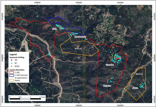
Figure 1 . Barroso Lithium Project summary map showing deposits and drill hole locations.
Pinheiro
The current JORC Resource estimate for the Pinheiro deposit (all Inferred as at May 2024) is 2.0Mt at 1.0% Li2O. Savannah is confident that this latest phase of drilling is likely to significantly increase the size and grade of the resource by outlining mineralised extensions of the Western Pegmatite to the south, and northern extensions to the Eastern Pegmatite. The Company expects that an increase in grade is also likely.
The highlight of the recent results has been a 67m intersection of mineralised pegmatite grading at 1.82% Li2O from hole 25PNRDD021, which was targeted to sit beneath the Scoping Study pit outline and was drilled slightly obliquely to the dip of the pegmatite (see Figures 2 and 3). The better recent results at Pinheiro are as follows:
o 67m @1.82% Li2O from 56m in hole 25PNRDD021
o 32m @1.66% Li2O from 27m in hole 25PNRRC036
o 24m @1.4% Li2O from 111m in hole 25PNRRC039
o 28m @1.13% Li2O from 32m in hole 25PNRRC040
o 23.8m @1.1% Li2O from 148.2m in hole 25PNRDD018
Figure 2. Location of Phase 2 drilling at Pinheiro with recent and selected significant intercepts to date.
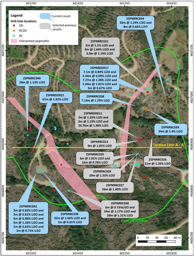
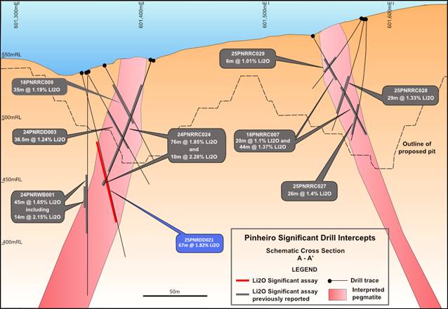
Figure 3 . Cross section through the Eastern and Western Pegmatites of the Pinheiro deposit (Section A-A').
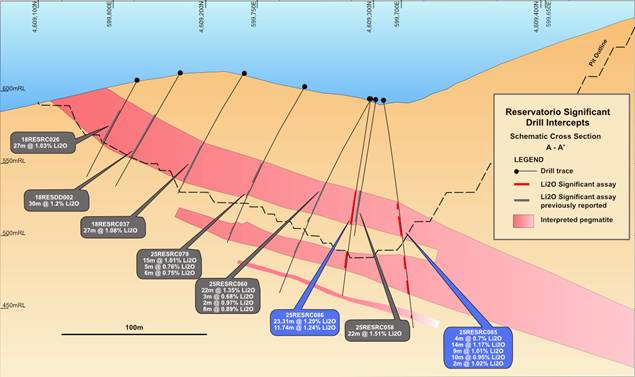
Reservatório
The current JORC Resource estimate for the Reservatório deposit (Indicated & Inferred as at May 2024) is 4.2Mt at 0.9% Li2O.
The current batch of results received for Reservatório further highlighted the continuation of lithium mineralisation at depth especially extending into the area where Savannah currently has an application to expand the C-100 Mining Licence boundary. The latest intersections outline the more complex morphology of the pegmatite body than was originally interpreted and indications are that the dip of the pegmatite is becoming shallower at depth, increasing its minable potential.
The recent batch of assays continue to highlight the strong consistency of the lithium mineralisation within the pegmatite at Reservatório and give a better understanding of the grade variations that are inherent in pegmatites due to textural and mineralogical changes.
Significant mineralised intersections from this batch of assays at Reservatório include:
o 32m @1.49% Li2O from 67m in hole 25RESRC087
o 25m @1.11% Li2O from 75m in hole 25RESRC088
o 23.31m @1.29% Li2O from 64m in hole 25RESRC086 and 11.74m @1.24% Li2O from 106.74m
o 23m @1.11% Li2O from 133m in hole 25RESRC073
o 14m @1.17% Li2O from 81m in hole 25RESRC085 and 9m @1.01% Li2O from 109m
Figure 4. Location of Phase 2 drilling at Reservatório with significant intercepts from assays results.
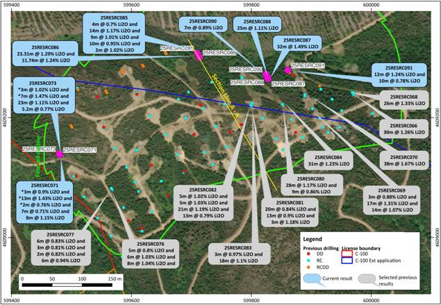
Figure 5 . Cross section through the Reservatório deposit (Section A - A').
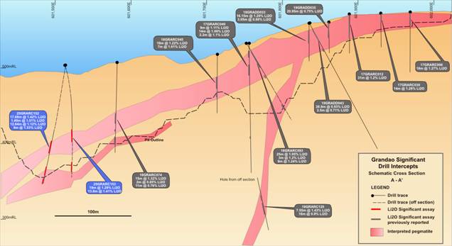
Grandão
The current JORC Resource estimate for the Grandão deposit (Measured, Indicated & Inferred as at May 2024) is 17.7Mt at 1.04% Li2O.
At Grandão the infill drilling of areas of the resource is complete, enabling Savannah to upgrade the JORC category in the potentially mineable portion of the pegmatite to a minimum Indicated level. The drilling of the southern extent of the pegmatite was also completed.
The results confirmed the excellent robustness of the lithium mineralisation at depth, especially in the western portion of the deposit, with grades seen to increase with depth. Pleasingly, the drilling also highlighted the occurrence of a smaller parallel pegmatite beneath the main orebody.
Significant mineralised intersections at Grandão in this set of assays include:
o 19m @1.29% Li2O from 92m in hole 25GRARC153 and 13.8m @1.41% Li2O from 139.2m.
o 17.68m @1.42% Li2O from 104.05m in hole 25GRARC152 and 12.64m @1.12% Li2O from 140.36m and 9m @1.53% Li2O from 156m.
o 4m @1.07% Li2O from 111m in hole 25GRARC149 and 9m @1.53% Li2O from 123m.
Figure 6. Location of Phase 2 drilling at Grandão with significant intercepts from assays results.
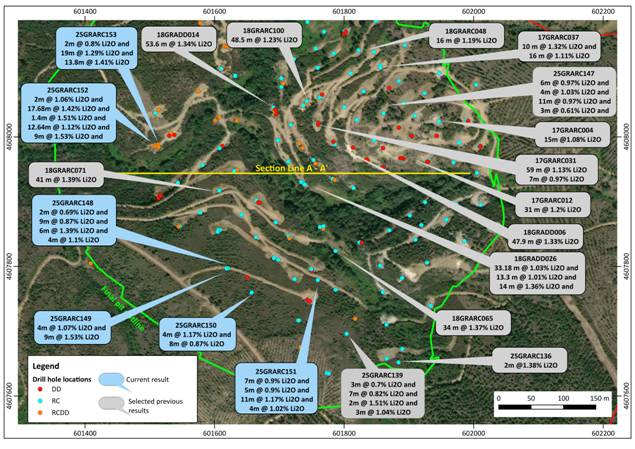
Figure 7 . Cross section through the Grandão deposit (Section A - A')
Sample collection for metallurgical testwork
In conjunction with resource drilling, diamond drilling for metallurgical samples was also carried out and in conjunction with Savannah's metallurgical consultants, specific samples have been selected and sent for metallurgical testing.
Next steps
The resource-focused stage of the Phase 2 drilling is now complete and the results from this will feed into upgrading the confidence level of the existing JORC resource estimates for each deposit and potentially increasing the overall resource tonnage at certain deposits. Updated or maiden Exploration Targets will also be produced in the coming weeks for each deposit as well as a first regional Exploration Target for the remainder of the C-100 Mining Licence.
Away from the resource-related work, metallurgical testwork will be conducted on the samples sent to our consultants and the resulting data used in the DFS, while the geotechnical data collected from each deposit will aid in the design of the various mining pits to ensure maximum extraction of ore under safe and sustainable conditions.
Background on the JORC Code
The Australasian Code for Reporting of Exploration Results, Mineral Resources and Ore Reserves ('the JORC Code') is a professional code of practice that sets minimum standards for Public Reporting of minerals Exploration Results, Mineral Resources and Ore Reserves.
The JORC Code provides a mandatory system for the classification of minerals Exploration Results, Mineral Resources and Ore Reserves according to the levels of confidence in geological knowledge and technical and economic considerations in Public Reports.
Public Reports prepared in accordance with the JORC Code are reports prepared for the purpose of informing investors or potential investors and their advisors.
The JORC Code was first published in 1989, with the most recent revision being published late in 2012.
JORC Code Definitions
| Category | Definition |
| Exploration Target | A statement or estimate of the exploration potential of a mineral deposit in a defined geological setting where the statement or estimate, quoted as a range of tonnes and a range of grade (or quality), relates to mineralisation for which there has been insufficient exploration to estimate a Mineral Resource. |
| Mineral Resource | A concentration or occurrence of solid material of economic interest in or on the Earth's crust in such form, grade (or quality), and quantity that there are reasonable prospects for eventual economic extraction. The location, quantity, grade (or quality), continuity and other geological characteristics of a Mineral Resource are known, estimated or interpreted from specific geological evidence and knowledge, including sampling. Mineral Resources are sub-divided, in order of increasing geological confidence, into Inferred, Indicated and Measured categories. |
| Inferred Mineral Resource | That part of a Mineral Resource for which quantity and grade (or quality) are estimated on the basis of limited geological evidence and sampling. Geological evidence is sufficient to imply but not verify geological and grade (or quality) continuity. It is based on exploration, sampling and testing information gathered through appropriate techniques from locations such as outcrops, trenches, pits, workings and drill holes. An Inferred Mineral Resource must not be converted to an Ore Reserve. It is reasonably expected that the majority of Inferred Mineral Resources could be upgraded to Indicated Mineral Resources with continued exploration. |
| Indicated Mineral Resource | That part of a Mineral Resource for which quantity, grade (or quality), densities, shape and physical characteristics are estimated with sufficient confidence to allow the application of Modifying Factors in sufficient detail to support mine planning and evaluation of the economic viability of the deposit. Geological evidence is derived from adequately detailed and reliable exploration, sampling and testing gathered through appropriate techniques from locations such as outcrops, trenches, pits, workings and drill holes, and is sufficient to assume geological and grade (or quality) continuity between points of observation where data and samples are gathered. An Indicated Mineral Resource has a lower level of confidence than that applying to a Measured. Mineral Resource and may only be converted to a Probable Ore Reserve. |
| Measured Mineral Resource | that part of a Mineral Resource for which quantity, grade (or quality), densities, shape, and physical characteristics are estimated with confidence sufficient to allow the application of Modifying Factors to support detailed mine planning and final evaluation of the economic viability of the deposit. Geological evidence is derived from detailed and reliable exploration, sampling and testing gathered through appropriate techniques from locations such as outcrops, trenches, pits, workings and drill holes, and is sufficient to confirm geological and grade (or quality) continuity between points of observation where data and samples are gathered. A Measured Mineral Resource has a higher level of confidence than that applying to either an Indicated Mineral Resource or an Inferred Mineral Resource. It may be converted to a Proved Ore Reserve or under certain circumstances to a Probable Ore Reserve. |
| Ore Reserve | Is the economically mineable part of a Measured and/or Indicated Mineral Resource. It includes diluting materials and allowances for losses, which may occur when the material is mined or extracted and is defined by studies at Pre-Feasibility or Feasibility level as appropriate that include application of Modifying Factors. Such studies demonstrate that, at the time of reporting, extraction could reasonably be justified. The reference point at which Reserves are defined, usually the point where the ore is delivered to the processing plant, must be stated. It is important that, in all situations where the reference point is different, such as for a saleable product, a clarifying statement is included to ensure that the reader is fully informed as to what is being reported. |
Figure 8 . The JORC Classification Framework
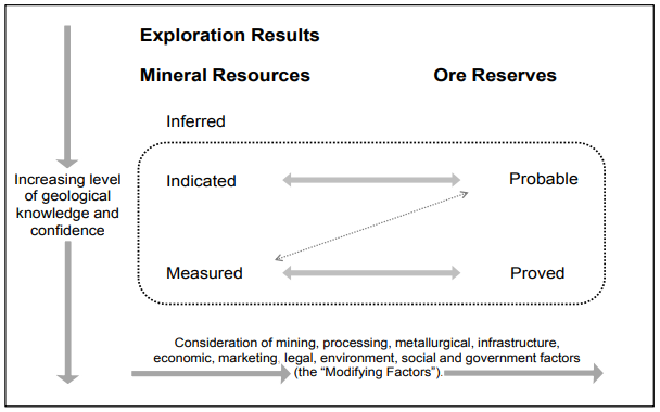
Source: JORC Code
Competent Person and Regulatory Information
The information in this announcement that relates to exploration results is based upon information compiled by Mr Dale Ferguson, Technical Director of Savannah Resources Limited. Mr Ferguson is a Member of the Australasian Institute of Mining and Metallurgy (AusIMM) and has sufficient experience which is relevant to the style of mineralisation and type of deposit under consideration and to the activity which he is undertaking to qualify as a Competent Person as defined in the December 2012 edition of the "Australasian Code for Reporting of Exploration Results, Mineral Resources and Ore Reserves" (JORC Code). Mr Ferguson consents to the inclusion in the report of the matters based upon the information in the form and context in which it appears.
Regulatory Information
This Announcement contains inside information for the purposes of the UK version of the market abuse regulation (EU No. 596/2014) as it forms part of United Kingdom domestic law by virtue of the European Union (Withdrawal) Act 2018 ("UK MAR").
Savannah - Enabling Europe's energy transition.
**ENDS**

Follow @SavannahRes on X (Formerly known as Twitter)
 Follow Savannah Resources on LinkedIn
For further information please visit www.savannahresources .com or contact:
| Savannah Resources PLC Emanuel Proença, CEO |
Tel: +44 20 7117 2489 |
| SP Angel Corporate Finance LLP (Nominated Advisor & Broker) David Hignell/ Charlie Bouverat (Corporate Finance) Grant Barker/Abigail Wayne (Sales & Broking) |
Tel: +44 20 3470 0470 |
| Canaccord Genuity Limited (Joint Broker) James Asensio / Charlie Hammond (Corporate Broking) Ben Knott (Sales) |
Tel: +44 20 7523 8000 |
| Media Relations Savannah Resources: Antonio Neves Costa, Communications Manager |
Tel: +351 962 678 912 |
About Savannah
Savannah Resources is a mineral resource development company and the sole owner of the Barroso Lithium Project (the 'Project') in northern Portugal. The Project is the largest battery grade spodumene lithium resource outlined to date in Europe and was classified as a 'Strategic Project' by the European Commission under the Critical Raw Materials Act in March 2025.
Through the Project, Savannah will help Portugal to play an important role in providing a long-term, locally sourced, lithium raw material supply for Europe's lithium battery value chain. Once in operation the Project will produce enough lithium (contained in c.190,000tpa of spodumene concentrate) for approximately half a million vehicle battery packs per year and hence make a significant contribution towards the European Commission's Critical Raw Material Act goal of a minimum 10% of European endogenous lithium production from 2030.
Savannah is focused on the responsible development and operation of the Barroso Lithium Project so that its impact on the environment is minimised and the socio-economic benefits that it can bring to all its stakeholders are maximised.
The Company is listed and regulated on the London Stock Exchange's Alternative Investment Market (AIM) and trades under the ticker "SAV".
APPENDIX 1: Drill hole locations of Completed Phase 2 RC and Diamond Resource Holes (* with assays)
| Hole ID | Prospect | Hole Type | Tot Depth (m) | Easting | Northing | RL | Dip | Azimuth |
| 25GRADD048 | Grandão | DD | 128.25 | 601650 | 4607783 | 568 | -50 | 189 |
| 25GRADD049 | Grandão | DD | 120.7 | 601517 | 4607910 | 507 | -50 | 229 |
| 25GRADD050 | Grandão | DD | 165.8 | 601547 | 4608217 | 536 | -90 | 0 |
| 25GRADD051 | Grandão | DD | 167.3 | 601553 | 4608216 | 536 | -60 | 184 |
| 25GRADD052 | Grandão | DD | 210.75 | 601538 | 4608003 | 519 | -50 | 309 |
| 25GRARC134 | Grandão | RC | 30 | 601928 | 4607806 | 578 | -90 | 0 |
| 25GRARC135 | Grandão | RC | 50 | 601890 | 4607673 | 587 | -90 | 0 |
| 25GRARC136 | Grandão | RC | 40 | 601884 | 4607652 | 595 | -90 | 0 |
| 25GRARC137 | Grandão | RC | 80 | 601773 | 4607636 | 607 | -90 | 0 |
| 25GRARC138 | Grandão | RC | 80 | 601776 | 4607634 | 607 | -60 | 89 |
| 25GRARC139 | Grandão | RC | 84 | 601804 | 4607696 | 577 | -90 | 0 |
| 25GRARC140 | Grandão | RCDD | 70.75 | 601817 | 4607719 | 562 | -90 | 0 |
| 25GRARC141 | Grandão | RC | 90 | 601787 | 4607764 | 551 | -72 | 89 |
| 25GRARC142 | Grandão | RCDD | 110.5 | 601735 | 4607676 | 597 | -60 | 89 |
| 25GRARC143 | Grandão | RCDD | 146.55 | 601733 | 4607676 | 597 | -90 | 0 |
| 25GRARC144 | Grandão | RC | 170 | 601731 | 4607717 | 582 | -70 | 89 |
| 25GRARC145 | Grandão | RC | 142 | 601729 | 4607717 | 583 | -90 | 0 |
| 25GRARC146 | Grandão | RCDD | 122.25 | 601635 | 4608025 | 505 | -60 | 119 |
| 25GRARC147 | Grandão | RC | 141 | 601742 | 4608055 | 540 | -65 | 44 |
| 25GRARC148 | Grandão* | RC | 160 | 601621 | 4607797 | 569 | -75 | 89 |
| 25GRARC149 | Grandão* | RC | 170 | 601619 | 4607797 | 569 | -90 | 0 |
| 25GRARC150 | Grandão* | RC | 152 | 601657 | 4607760 | 575 | -90 | 0 |
| 25GRARC151 | Grandão* | RC | 93 | 601759 | 4607779 | 550 | -60 | 89 |
| 25GRARC152 | Grandão* | RCDD | 175.75 | 601513 | 4607988 | 503 | -80 | 219 |
| 25GRARC153 | Grandão* | RCDD | 161.2 | 601514 | 4607984 | 503 | -70 | 139 |
| 25PNRDD009 | Pinheiro | DD | 84.85 | 601595 | 4606830 | 581 | -60 | 269 |
| 25PNRDD010 | Pinheiro | DD | 110.35 | 601590 | 4606831 | 584 | -57 | 214 |
| 25PNRDD011 | Pinheiro | DD | 120.75 | 601583 | 4606910 | 576 | -50 | 262 |
| 25PNRDD012 | Pinheiro | DD | 101.2 | 601580 | 4606910 | 576 | -50 | 62 |
| 25PNRDD013 | Pinheiro | DD | 124.9 | 601399 | 4606803 | 539 | -60 | 89 |
| 25PNRDD014 | Pinheiro | DD | 111.8 | 601415 | 4606856 | 561 | -50 | 184 |
| 25PNRDD015 | Pinheiro | DD | 126.8 | 601598 | 4607012 | 584 | -50 | 309 |
| 25PNRDD016 | Pinheiro | DD | 108.3 | 601400 | 4606802 | 539 | -50 | 109 |
| 25PNRDD017 | Pinheiro* | DD | 100.1 | 601599 | 4607011 | 583 | -62 | 309 |
| 25PNRDD018 | Pinheiro* | DD | 179.55 | 601638 | 4606995 | 573 | -55 | 229 |
| 25PNRDD019 | Pinheiro | DD | 140.19 | 601608 | 4606921 | 573 | -50 | 294 |
| 25PNRDD020 | Pinheiro | DD | 85.85 | 601581 | 4606910 | 575 | -50 | 329 |
| 25PNRDD021 | Pinheiro* | DD | 152.5 | 601350 | 4606883 | 537 | -75 | 89 |
| 25PNRRC026 | Pinheiro | RCDD | 120 | 601608 | 4606921 | 573 | -70 | 269 |
| 25PNRRC027 | Pinheiro | RC | 100 | 601579 | 4606880 | 582 | -90 | 0 |
| 25PNRRC028 | Pinheiro | RCDD | 94.3 | 601577 | 4606879 | 582 | -80 | 269 |
| 25PNRRC029 | Pinheiro | RC | 70 | 601575 | 4606878 | 582 | -60 | 269 |
| 25PNRRC030 | Pinheiro | RC | 70 | 601431 | 4606801 | 554 | -60 | 89 |
| 25PNRRC031 | Pinheiro | RCDD | 128.55 | 601600 | 4607010 | 583 | -60 | 244 |
| 25PNRRC032 | Pinheiro | RC | 100 | 601639 | 4607037 | 584 | -60 | 269 |
| 25PNRRC033 | Pinheiro | RCDD | 131.5 | 601637 | 4606996 | 573 | -60 | 269 |
| 25PNRRC034 | Pinheiro | RC | 85 | 601665 | 4607062 | 591 | -60 | 269 |
| 25PNRRC035 | Pinheiro | RC | 110 | 601590 | 4606977 | 572 | -60 | 269 |
| 25PNRRC036 | Pinheiro* | RC | 100 | 601371 | 4606845 | 546 | -60 | 49 |
| 25PNRRC037 | Pinheiro* | RC | 151 | 601428 | 4606901 | 545 | -60 | 134 |
| 25PNRRC038 | Pinheiro* | RCDD | 155.5 | 601592 | 4606976 | 572 | -70 | 269 |
| 25PNRRC039 | Pinheiro* | RCDD | 143.35 | 601600 | 4606972 | 572 | -64 | 219 |
| 25PNRRC040 | Pinheiro* | RC | 70 | 601343 | 4606919 | 540 | -65 | 79 |
| 25PNRRC041 | Pinheiro* | RC | 80 | 601332 | 4606963 | 553 | -70 | 89 |
| 25PNRRC042 | Pinheiro* | RC | 158 | 601364 | 4606841 | 544 | -70 | 89 |
| 25RESDD015 | Reservatório | DD | 150.8 | 599508 | 4609103 | 618 | -50 | 221 |
| 25RESDD016 | Reservatório | DD | 90.8 | 599869 | 4609271 | 577 | -50 | 349 |
| 25RESRC046 | Reservatório | RCDD | 184.8 | 599584 | 4609279 | 639 | -80 | 149 |
| 25RESRC047 | Reservatório | RCDD | 178.7 | 599586 | 4609276 | 639 | -65 | 149 |
| 25RESRC048 | Reservatório | RCDD | 186.5 | 599499 | 4609187 | 642 | -90 | 0 |
| 25RESRC049 | Reservatório | RCDD | 174 | 599501 | 4609184 | 642 | -70 | 149 |
| 25RESRC050 | Reservatório | RCDD | 140.1 | 599520 | 4609147 | 631 | -63 | 149 |
| 25RESRC051 | Reservatório | RCDD | 160.4 | 599618 | 4609288 | 621 | -80 | 149 |
| 25RESRC052 | Reservatório | RCDD | 158.8 | 599620 | 4609286 | 620 | -70 | 149 |
| 25RESRC053 | Reservatório | RC | 111 | 599695 | 4609243 | 614 | -90 | 0 |
| 25RESRC054 | Reservatório | RCDD | 150.4 | 599656 | 4609310 | 604 | -90 | 0 |
| 25RESRC055 | Reservatório | RCDD | 145.1 | 599658 | 4609307 | 604 | -70 | 149 |
| 25RESRC056 | Reservatório | RCDD | 136.25 | 599914 | 4609253 | 577 | -80 | 359 |
| 25RESRC057 | Reservatório | RC | 88 | 599916 | 4609248 | 577 | -60 | 139 |
| 25RESRC058 | Reservatório | RC | 96 | 599710 | 4609302 | 594 | -80 | 149 |
| 25RESRC059 | Reservatório | RC | 100 | 599951 | 4609212 | 586 | -60 | 149 |
| 25RESRC060 | Reservatório | RC | 147 | 599713 | 4609299 | 593 | -60 | 149 |
| 25RESRC061 | Reservatório | RC | 120 | 599784 | 4609267 | 588 | -70 | 309 |
| 25RESRC062 | Reservatório | RC | 120 | 599784 | 4609267 | 588 | -90 | 0 |
| 25RESRC063 | Reservatório | RC | 67 | 599935 | 4609231 | 581 | -60 | 149 |
| 25RESRC064 | Reservatório | RC | 55 | 599970 | 4609239 | 576 | -60 | 149 |
| 25RESRC065 | Reservatório | RC | 140 | 599504 | 4609102 | 618 | -60 | 149 |
| 25RESRC066 | Reservatório | RC | 70 | 599970 | 4609242 | 576 | -80 | 359 |
| 25RESRC067 | Reservatório | RCDD | 160.8 | 599481 | 4609137 | 628 | -65 | 149 |
| 25RESRC068 | Reservatório | RC | 94 | 599968 | 4609242 | 576 | -60 | 339 |
| 25RESRC069 | Reservatório | RC | 91 | 599902 | 4609215 | 594 | -60 | 149 |
| 25RESRC070 | Reservatório | RC | 100 | 599889 | 4609236 | 589 | -60 | 149 |
| 25RESRC071 | Reservatório* | RCDD | 164.1 | 599480 | 4609138 | 628 | -75 | 149 |
| 25RESRC072 | Reservatório | RC | 85 | 599889 | 4609238 | 589 | -90 | 0 |
| 25RESRC073 | Reservatório* | RCDD | 177.25 | 599480 | 4609140 | 628 | -85 | 149 |
| 25RESRC074 | Reservatório | RC | 90 | 599587 | 4609050 | 608 | -60 | 149 |
| 25RESRC075 | Reservatório | RCDD | 93.9 | 599864 | 4609275 | 577 | -70 | 149 |
| 25RESRC076 | Reservatório | RC | 100 | 599568 | 4609080 | 614 | -60 | 149 |
| 25RESRC077 | Reservatório | RC | 105 | 599566 | 4609082 | 614 | -80 | 149 |
| 25RESRC078 | Reservatório | RCDD | 111.8 | 599864 | 4609276 | 577 | -90 | 0 |
| 25RESRC079 | Reservatório | RC | 121 | 599734 | 4609259 | 603 | -60 | 149 |
| 25RESRC080 | Reservatório | RC | 122 | 599800 | 4609220 | 607 | -60 | 149 |
| 25RESRC081 | Reservatório | RC | 133 | 599799 | 4609221 | 607 | -90 | 0 |
| 25RESRC082 | Reservatório | RC | 147 | 599801 | 4609224 | 607 | -70 | 329 |
| 25RESRC083 | Reservatório | RC | 107 | 599853 | 4609221 | 600 | -60 | 149 |
| 25RESRC084 | Reservatório | RC | 111 | 599852 | 4609222 | 600 | -90 | 0 |
| 25RESRC085 | Reservatório | RC | 160 | 599710 | 4609308 | 594 | -80 | 329 |
| 25RESRC086 | Reservatório* | RCDD | 136.9 | 599713 | 4609301 | 594 | -80 | 149 |
| 25RESRC087 | Reservatório* | RC | 109 | 599828 | 4609265 | 585 | -60 | 149 |
| 25RESRC088 | Reservatório* | RC | 116 | 599827 | 4609267 | 585 | -80 | 149 |
| 25RESRC089 | Reservatório* | RC | 120 | 599825 | 4609271 | 585 | -75 | 329 |
| 25RESRC090 | Reservatório* | RC | 153 | 599824 | 4609273 | 585 | -60 | 329 |
| 25RESRC091 | Reservatório* | RC | 135 | 599861 | 4609279 | 577 | -70 | 329 |
APPENDIX 2 - Summary of Significant Intercepts from the diamond drilling using a 0.5% Li2O Cutoff.
| HoleID | Prospect | From | To | Width | Li2O |
| 25GRARC148 | Grandão | 96 | 98 | 2 | 0.69 |
| and | Grandão | 101 | 110 | 9 | 0.87 |
| and | Grandão | 120 | 126 | 6 | 1.39 |
| and | Grandão | 131 | 135 | 4 | 1.1 |
| 25GRARC149 | Grandão | 111 | 115 | 4 | 1.07 |
| and | Grandão | 123 | 132 | 9 | 1.53 |
| 25GRARC150 | Grandão | 89 | 93 | 4 | 1.17 |
| and | Grandão | 98 | 106 | 8 | 0.87 |
| 25GRARC151 | Grandão | 29 | 36 | 7 | 0.9 |
| and | Grandão | 40 | 45 | 5 | 0.9 |
| and | Grandão | 59 | 70 | 11 | 1.17 |
| and | Grandão | 74 | 78 | 4 | 1.02 |
| 25GRARC152 | Grandão | 6 | 8 | 2 | 1.06 |
| and | Grandão | 104.05 | 121.73 | 17.68 | 1.42 |
| and | Grandão | 126.46 | 127.86 | 1.4 | 1.51 |
| and | Grandão | 140.36 | 153 | 12.64 | 1.12 |
| and | Grandão | 156 | 165 | 9 | 1.53 |
| 25GRARC153 | Grandão | 2 | 4 | 2 | 0.8 |
| and | Grandão | 92 | 111 | 19 | 1.29 |
| and | Grandão | 139.2 | 153 | 13.8 | 1.41 |
| 25PNRDD017 | Pinheiro | 11.75 | 18.85 | 7.1 | 0.84 |
| and | Pinheiro | 21.88 | 27.32 | 5.44 | 0.69 |
| and | Pinheiro | 32.73 | 40 | 7.27 | 1.38 |
| and | Pinheiro | 46.67 | 48.31 | 1.64 | 1.01 |
| and | Pinheiro | 54.33 | 57.33 | 3 | 0.67 |
| 25PNRDD018 | Pinheiro | 148.2 | 172 | 23.8 | 1.1 |
| 25PNRDD021 | Pinheiro | 56 | 123 | 67 | 1.82 |
| 25PNRRC036 | Pinheiro | 27 | 59 | 32 | 1.66 |
| and | Pinheiro | 63 | 65 | 2 | 0.65 |
| 25PNRRC037 | Pinheiro | 15 | 18 | 3 | 0.8 |
| 25PNRRC038 | Pinheiro | 138 | 145.14 | 7.14 | 1.29 |
| 25PNRRC039 | Pinheiro | 111 | 135 | 24 | 1.4 |
| 25PNRRC040 | Pinheiro | 32 | 60 | 28 | 1.13 |
| 25PNRRC041 | Pinheiro | No Significant Assays | |||
| 25PNRRC042 | Pinheiro | 81 | 84 | 3 | 0.83 |
| and | Pinheiro | 96 | 98 | 2 | 0.81 |
| and | Pinheiro | 107 | 113 | 6 | 0.88 |
| and | Pinheiro | 126 | 132 | 6 | 1.26 |
| and | Pinheiro | 135 | 137 | 2 | 0.82 |
| and | Pinheiro | 140 | 142 | 2 | 0.73 |
| 25RESRC071* | Reservatório | 141 | 148 | 7 | 0.71 |
| and | Reservatório | 154 | 162 | 8 | 1.15 |
| 25RESRC073* | Reservatório | 133 | 156 | 23 | 1.11 |
| and | Reservatório | 162.5 | 167.7 | 5.2 | 0.77 |
| 25RESRC085 | Reservatório | 72 | 76 | 4 | 0.7 |
| and | Reservatório | 81 | 95 | 14 | 1.17 |
| and | Reservatório | 109 | 118 | 9 | 1.01 |
| and | Reservatório | 126 | 136 | 10 | 0.95 |
| and | Reservatório | 150 | 152 | 2 | 1.02 |
| 25RESRC086 | Reservatório | 64 | 87.31 | 23.31 | 1.29 |
| and | Reservatório | 106.74 | 118.48 | 11.74 | 1.24 |
| 25RESRC087 | Reservatório | 67 | 99 | 32 | 1.49 |
| 25RESRC088 | Reservatório | 75 | 100 | 25 | 1.11 |
| 25RESRC089 | Reservatório | No Significant Assays | |||
| 25RESRC090 | Reservatório | 107 | 114 | 7 | 0.89 |
| 25RESRC091 | Reservatório | 87 | 99 | 12 | 1.24 |
| and | Reservatório | 102 | 112 | 10 | 0.78 |
* Results from completed diamond tail
APPENDIX 3 - JORC 2012 Table 1 - DFS Infill Drilling
JORC Table 1 Section 1 Sampling Techniques and Data
| Criteria | JORC Code Explanation | Commentary |
|---|---|---|
| Sampling techniques | · Nature and quality of sampling (e.g. cut channels, random chips, or specific specialised industry standard measurement tools appropriate to the minerals under investigation, such as down hole gamma sondes, or handheld XRF instruments, etc). These examples should not be taken as limiting the broad meaning of sampling. · Include reference to measures taken to ensure sample representivity and the appropriate calibration of any measurement tools or systems used. · Aspects of the determination of mineralisation that are Material to the Public Report. In cases where 'industry standard' work has been done this would be relatively simple (e.g. 'reverse circulation drilling was used to obtain 1 m samples from which 3 kg was pulverised to produce a 30 g charge for fire assay'). In other cases more explanation may be required, such as where there is coarse gold that has inherent sampling problems. Unusual commodities or mineralisation types (e.g. submarine nodules) may warrant disclosure of detailed information. |
· The majority of previous holes were reverse circulation, sampled at 1m intervals. RC samples were collected in large plastic bags attached to the cyclone. On completion of the 1m run the large sample was passed through a 3-stage riffle splitter to collect a 2.5-4kg sub sample, to be used for assay. · Diamond holes were completed for metallurgical sampling, geotechnical analysis and resource estimation. Core was PQ/HQ size, sampled at 1m intervals in the pegmatite, with boundaries sampled to geological boundaries. Half core samples were collected for analysis. · Drilling was carried out to infill previous drilling to achieve a nominal 40m by 40m spacing with selected infill to 40m by 20m spacings, or as twins of previous RC drilling to get known samples for metallurgical testing. Geotechnical drilling was designed purely to intersect planned pit walls and pegmatite intersections were incidental, but followed all standard logging and sampling in line with all the drilling. · Collar surveys are carried using differential DGPS with an accuracy to within 0.2m. · A down hole survey for each hole was completed using gyro equipment. · The lithium mineralisation is predominantly in the form of Spodumene-bearing pegmatites, the pegmatites are unzoned and vary in thickness from 5m-109m. |
| Drilling techniques | · Drill type (e.g. core, reverse circulation, open-hole hammer, rotary air blast, auger, Bangka, sonic, etc) and details (e.g. core diameter, triple or standard tube, depth of diamond tails, face-sampling bit or other type, whether core is oriented and if so, by what method, etc). | • RC drilling used a 120mm diameter face sampling hammer. · Core drilling was carried out using PQ/HQ single tube core barrels. |
| Drill sample recovery | · Method of recording and assessing core and chip sample recoveries and results assessed. · Measures taken to maximise sample recovery and ensure representative nature of the samples. · Whether a relationship exists between sample recovery and grade and whether sample bias may have occurred due to preferential loss/gain of fine/coarse material. |
· RC drilling sample weights were monitored to ensure samples were maximised. Samples were carefully loaded into a splitter and split in the same manner ensuring that the sample split to be sent to the assay laboratories were in the range of 4-6kg. · Core recovery was measured and was found to be generally excellent. · No obvious relationships between sample recovery and grade. |
| Logging | · Whether core and chip samples have been geologically and geotechnically logged to a level of detail to support appropriate Mineral Resource estimation, mining studies and metallurgical studies. · Whether logging is qualitative or quantitative in nature. Core (or costean, channel, etc) photography. · The total length and percentage of the relevant intersections logged. |
· RC holes were logged in the field at the time of sampling. Core was logged in detail for a variety of physical characteristics in a logging yard away from the drilling · Each 1m sample interval was carefully homogenised and assessed for lithology, colour, grainsize, structure and mineralisation. Core was sampled to geological boundaries and at 1m intervals therein. · A representative chip sample produced from RC drilling was washed and taken for each 1m sample and stored in a chip tray which was photographed. · Percussion holes were logged for every metre drilled with the spoil collected for each metre by shovel and placed in a sample bag, a representative sub sample was taken and logged for lithology, colour, grainsize and mineralisation. · Core was photographed. |
| Sub-sampling techniques and sample preparation | · If core, whether cut or sawn and whether quarter, half or all core taken. · If non-core, whether riffled, tube sampled, rotary split, etc and whether sampled wet or dry. · For all sample types, the nature, quality and appropriateness of the sample preparation technique. · Quality control procedures adopted for all sub-sampling stages to maximise representivity of samples. · Measures taken to ensure that the sampling is representative of the in-situ material collected, including for instance results for field duplicate/second-half sampling. · Whether sample sizes are appropriate to the grain size of the material being sampled. |
· 1m RC samples were split by the riffle splitter at the drill rig and sampled dry. · Core was cut in half using a diamond saw with 1m half core samples submitted for analysis or for metallurgical samples one of the halves was cut again for a quarter core and sent for analysis. · The sampling was conducted using industry standard techniques and were considered appropriate. · Field duplicates were used to test repeatability of the sub-sampling and were found to be satisfactory. · Every effort was made to ensure that the samples were representative and not biased in any way. |
| Quality of assay data and laboratory tests | · The nature, quality and appropriateness of the assaying and laboratory procedures used and whether the technique is considered partial or total. · For geophysical tools, spectrometers, handheld XRF instruments, etc, the parameters used in determining the analysis including instrument make and model, reading times, calibrations factors applied and their derivation, etc. · Nature of quality control procedures adopted (e.g. standards, blanks, duplicates, external laboratory checks) and whether acceptable levels of accuracy (i.e. lack of bias) and precision have been established. |
· Samples were received, sorted, labelled, and dried. · Samples were crushed to 70% less than 2mm, riffle split off 250g, pulverise split to better than 85% passing 75 microns and 5g was split of for assaying. · The samples were analysed using ALS Laboratories ME-MS89L Super Trace method which combines a sodium peroxide fusion with ICP-MS instrumentation utilising collision/reaction cell technologies to provide the lowest detection limits available. · A prepared sample (0.2g) is added to sodium peroxide flux, mixed well and then fused in at 670°C. The resulting melt is cooled and then dissolved in 30% hydrochloric acid. This solution is then analysed by ICP-MS and the results are corrected for spectral inter-element interferences. · The final solution is then analysed by ICP-MS, with results corrected for spectral inter-element interferences. · Standards/blanks and duplicates were inserted on a 1:20 ratio for both to samples taken. · Duplicate sample regime is used to monitor sampling methodology and homogeneity. · Routine QA/QC controls for the method ME-MS89L include blanks, certified reference standards of Lithium and duplicate samples. Samples are assayed within runs or batches up to 150 samples. At the fusion stage that quality control samples are included together with the samples, so all samples follow the same procedure until the end. Fused and diluted samples are prepared for ICP-MS analysis. ICP instrument is calibrated through appropriate certified standards solutions and interference corrections to achieve strict calibration fitting parameters. Each 40-sample run is assayed with two blanks, two certified standards and one duplicate sample and results are evaluated accordingly. · A QA/QC review of all information indicated that all assays were satisfactory. |
| Verification of sampling and assaying | · The verification of significant intersections by either independent or alternative company personnel. · The use of twinned holes. · Documentation of primary data, data entry procedures, data verification, data storage (physical and electronic) protocols. · Discuss any adjustment to assay data. |
· All information was internally audited by company personnel. · During this programme no holes were twinned. · Savannah's experienced project geologists supervised all processes. · All field data is entered into a custom log sheet and then into excel spreadsheets (supported by look-up tables) at site and subsequently validated as it is imported into the centralised Access database. · Hard copies of logs, survey and sampling data are stored in the local office and electronic data is stored on the company's cloud drive. · Results were reported as Li (ppm) and were converted to a percentage by dividing by 10,000 and then to Li2O% by multiplying by 2.153. |
| Location of data points | · Accuracy and quality of surveys used to locate drill holes (collar and down-hole surveys), trenches, mine workings and other locations used in Mineral Resource estimation. · Specification of the grid system used. · Quality and adequacy of topographic control. |
· The coordinate of each drill hole was taken at the time of collecting using a handheld GPS with an accuracy of 5m. All collars were subsequently surveyed using DGPS with an accuracy of 0.2m. · The grid system used is WSG84 Zone29N. · An accurate, aerial topographic survey was obtained with accuracy of +/- 0.5m. |
| Data spacing and distribution | · Data spacing for reporting of Exploration Results. · Whether the data spacing and distribution is sufficient to establish the degree of geological and grade continuity appropriate for the Mineral Resource and Ore Reserve estimation procedure(s) and classifications applied. · Whether sample compositing has been applied. |
· Drilling was carried out on an infill basis to attain on a nominal 40m by 40m and based on geological targets with selected infill to 40m by 20m. · Drill data is considered of sufficient spacing to define Measured and Indicated Mineral Resource in accordance with requirements for a DFS · Compositing to 1m will be applied prior to resource estimation. |
| Orientation of data in relation to geological structure | · Whether the orientation of sampling achieves unbiased sampling of possible structures and the extent to which this is known, considering the deposit type. · If the relationship between the drilling orientation and the orientation of key mineralised structures is considered to have introduced a sampling bias, this should be assessed and reported if material. |
· Drilling was generally carried out using angled holes, as close to perpendicular to strike as possible. All Geotech holes were drilled in various orientations to intersect planned pit walls. According to the expert (GGC - Consultants) requirements. |
| Sample security | · The measures taken to ensure sample security. | · Samples were delivered to a courier and chain of custody is managed by Savannah. |
| Audits or reviews | · The results of any audits or reviews of sampling techniques and data. | · Internal company auditing based on previous programmes is carried out and an external review will be carried out by the resource consultant to assure that all data collection and QA/QC procedures were conducted to industry standards. |
JORC Table 1 Section 2 Reporting of Exploration Results
| Criteria | JORC Code explanation | Commentary |
|---|---|---|
| Mineral tenement and land tenure status | · Type, reference name/number, location and ownership including agreements or material issues with third parties such as joint ventures, partnerships, overriding royalties, native title interests, historical sites, wilderness or national park and environmental settings. · The security of the tenure held at the time of reporting along with any known impediments to obtaining a license to operate in the area. |
· All work was completed inside the Mina do Barroso project C-100. · Savannah has received written confirmation from the DGEG that under article 24 of Decree-Law no. 88/90 of March 16 being relevant justification based on the resources allocated exploited and intended, Savannah has been approved an expansion up to 250m of C100 mining concession in specific areas where a resource has been defined and the requirement for the expansion can be justified. · The entire drill programme was carried out over land that was granted by an administrative easement right defined in the C-100 mining contract. The easement covered private and public land that was within the C-100 license area. |
| Exploration done by other parties | · Acknowledgment and appraisal of exploration by other parties. | · Limited exploration work has been carried out by previous operators. · No historic information has been included in the Mineral Resource estimates. |
| Geology | · Deposit type, geological setting and style of mineralisation. | · The lithium mineralisation is predominantly in the form of Spodumene-bearing pegmatites which are hosted in meta-pelitic and mica schists, and occasionally carbonate schists of upper Ordovician to lower Devonian age. The pegmatites vary in thickness from 5m-109m. The pegmatites occur within the license area as discrete bodies and currently four pegmatite bodies have a resource defined on them. The pegmatites vary in orientation from large shallow dipping bodies, such as the north - south striking Grandão and the east - west trending Reservatório to steeply dipping dyke like bodies seen at NOA and Pinheiro. |
| Drill hole information | · A summary of all information material to the under-standing of the exploration results including a tabulation of the following information for all Material drill holes: · easting and northing of the drill hole collar · elevation or RL (Reduced Level - elevation above sea level in metres) of the drill hole collar · dip and azimuth of the hole · down hole length and interception depth · hole length · If the exclusion of this information is justified on the basis that the information is not Material and this exclusion does not detract from the understanding of the report, the Competent Person should clearly explain why this is the case. |
· A table containing all drill holes drilled and a list of significant assays from the results received is included with the release. · No material data has been excluded from the release. . |
| Data aggregation methods | · In reporting Exploration Results, weighting averaging techniques, maximum and/or minimum grade truncations (e.g. cutting of high grades) and cut-off grades are usually Material and should be stated. · Where aggregate intercepts incorporate short lengths of high-grade results and longer lengths of low grade results, the procedure used for such aggregation should be stated and some typical examples of such aggregations should be shown in detail. · The assumptions used for any reporting of metal equivalent values should be clearly stated. |
· Length weighted average grades have been reported. · No high-grade cuts have been applied to reported grades. · Metal equivalent values are not being reported; however, Li is reported as ppm and converted to the oxide Li2O for resource purposes. The conversion factor used is to divide the Li value by 10,000 and multiplying by 2.153 to represent the value as a percentage. |
| Relationship between mineralisation widths and intercept lengths | · These relationships are particularly important in the reporting of Exploration Results. · If the geometry of the mineralisation with respect to the drill hole angle is known, its nature should be reported. · If it is not known and only the down hole lengths are reported, there should be a clear statement to this effect (e.g. 'down hole length, true width not known'). |
· The majority of holes have been drilled at angles to intersect the mineralisation in perpendicular relation to the pegmatite |
| Diagrams | · Appropriate maps and sections (with scales) and tabulations of intercepts should be included for any significant discovery being reported. These should include, but not be limited to a plan view of drill hole collar locations and appropriate sectional views. | · A relevant plan showing the drilling is included within this release. |
| Balanced Reporting | · Accuracy and quality of surveys used to locate drill holes (collar and down-hole surveys), trenches, mine workings and other locations used in Mineral Resource estimation. · Where comprehensive reporting of all Exploration Results is not practicable, representative reporting of both low and high grades and/or widths should be practiced to avoid misleading reporting of Exploration Results. |
· All relevant results available have been previously reported. |
| Other substantive exploration data | · Other exploration data, if meaningful and material, should be reported including (but not limited to): geological observations; geophysical survey results; geochemical survey results; bulk samples - size and method of treatment; metallurgical test results; bulk density, groundwater, geotechnical and rock characteristics; potential deleterious or contaminating substances. | · Geological mapping and rock chip sampling has been conducted over the project area. |
| Further work | · The nature and scale of planned further work (e.g. tests for lateral extensions or depth extensions or large- scale step-out drilling). · Diagrams clearly highlighting the areas of possible extensions, including the main geological interpretations and future drilling areas, provided this information is not commercially sensitive. |
· The present drill programme has been designed to infill previous drilling to attain a measured or indicated class for an upcoming resource estimation. Further work is being planned as part of a second phase of resource infill drilling. · Economic evaluation of the defined Mineral Resources, will be completed after the second phase of drilling. |
This information is provided by RNS, the news service of the London Stock Exchange. RNS is approved by the Financial Conduct Authority to act as a Primary Information Provider in the United Kingdom. Terms and conditions relating to the use and distribution of this information may apply. For further information, please contact [email protected] or visit www.rns.com.
RNS may use your IP address to confirm compliance with the terms and conditions, to analyse how you engage with the information contained in this communication, and to share such analysis on an anonymised basis with others as part of our commercial services. For further information about how RNS and the London Stock Exchange use the personal data you provide us, please see our Privacy Policy.
END
DRLPKDBQPBKKBFB